Southern Archaeological Area
South of the Church of St. Shenoute, there are archaeological remains associated with manufacturing processes.
The southern archaeological area of the White Monastery is located to the south of the Church of St. Shenoute, on the west side of the main entrance. It was the first area to be excavated by the Supreme Council for Antiquities (SCA) when they began their investigation of the monastery in the 1980s. Recording and documentation was continued by Peter Grossmann (1989–2002) and the Consortium (2000–2007). YMAP’s ongoing work here began with Louise Blanke’s detailed study of the area for her doctoral research on the archaeology of monastic life at the White Monastery Federation.[1]
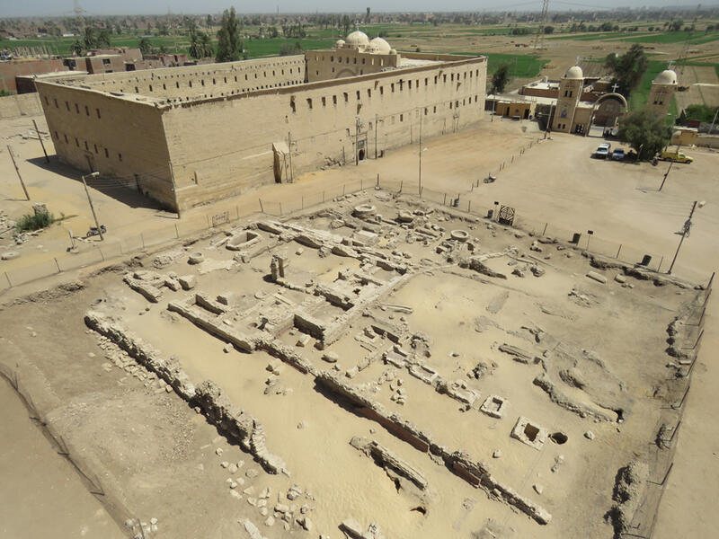
Figure 1. Southern archaeological area as it appeared after cleaning in 2018, looking north-east, with the Church of St. Shenoute behind.
Peter Grossmann and Darlene Brooks Hedstrom collaborated with members of the Egyptian excavation team to undertake initial recording and interpretation in the first phase of the Consortium’s work (2000–2004). Through their program of archaeological recording, planning, and photo-documentation, they were able to make preliminary identifications and interpretations of individual components of the area, especially the rectangular building (their “building with the cruciform pillars”) in its north east corner.[2] The southern archaeological area was not included in the scope of the Consortium’s second phase (2005–2007), which instead focused on recording in the western and northern parts of the site.[3]
Work in the southern archaeological area resumed in 2009 as part of the Yale Monastic Archaeology Project’s ongoing archaeological investigation of the monastery. Detailed archaeological recording, carefully targeted keyhole excavations, photo-documentation, and mapping were completed in 2009–2010 by Louise Blanke, assisted by Mohammed Khalifa (fig. 2). Study of in situ and excavated ceramics, including those retained by the SCA, was conducted by Gillian Pyke, also assisted by Mohammed Khalifa (fig. 3). The few objects and ceramic material found during the YMAP investigations were studied by Gillian Pyke in 2015. Documentation through digital archaeology was begun in 2018, when Alberto Urcia completed photogrammetry of the area. In 2019, the area was also included in the 3D laser-scanning survey by Pietro Gasparri, assisted by Giovanni Tamburro and Massimo Carderi (fig. 4). Preparatory cleaning, photo-documentation ahead of this work and the updating of conservation measures were undertaken by Gillian Pyke and Sharif Munir Adly.
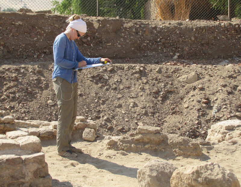
Figure 2. Louise Blanke working in the thoroughfare on the west side of the southern archaeological area in 2010.
Figure 3. Mohammed Khalifa reconstructing a pot in the central part of the southern archaeological area in 2009.
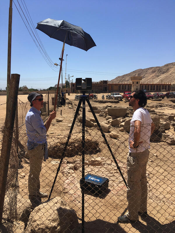
Figure 4. Pietro Gasparri and Massimo Carderi during 3D laser-scanning of the southern archaeological area in 2019. The shade is to stop the scanner from overheating.
Although it is much smaller than the archaeological area to the west of the Church of St. Shenoute, the southern archaeological area contains several similar architectural features. Their organization can be divided into four zones: west; center; south east; and north east. The main feature of the western zone is a north-south thoroughfare. The north part of the central zone is occupied by a rectangular building, with a series of tanks to the south. The south east zone is very poorly preserved, with scant traces of the original architectural features that include the continuation of the pipes of the north east zone, traces of walls, and mud sub-floors. The north east zone contains several water-supply pipes, a series of small rooms, and several granite crushing basins.
The north-south thoroughfare (fig. 5) on the west side of the area is slightly to the east of the similar thoroughfare in the western archaeological area, but its alignment matches it and the western wall of the Church of St. Shenoute. It is bounded by thick fired brick walls pierced by narrow windows that ventilated the adjacent buildings. There are traces of at least one water-supply pipe running along its length that was perhaps originally underground.[4]
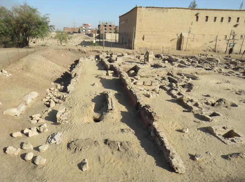
Figure 5. The thoroughfare at the western margin of the southern archaeological area after cleaning in 2018, looking north. The tank area is on the right.
Immediately to the east of the thoroughfare are the rectangular building (fig. 6) and tank complex (fig. 7). The building is positioned at the north end of the street and in its original form consisted of a large open courtyard with small rooms along its west and south sides. The courtyard contained floor-level features associated with processes involving liquids as well as an oven. Sherds in the subfloor suggest that it was laid in the fifth century or later. The courtyard was later roofed. A paved floor laid on a mud substructure including ceramics indicate that this modification occurred in about the seventh century. The addition of a large rectangular tank at the north end of the now-roofed space can be dated to the eighth century or later from pottery sherds used in its construction. The tank is fed via a pipe from the well in the south west corner of the Church of St. Shenoute. A cistern and pipework in the rooms on the south side of the rectangular building shows were also associated with water, some of which was directed towards the tanks to the south.[5]
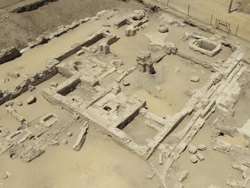
Figure 6. The rectangular building (center) with the thoroughfare (upper left), tanks (lower left), and passage/alley (right) as they appeared after cleaning in 2018, looking north west.
The series of six tanks extends southwards from the south wall of the rectangular building, ending with a ceramic soak-away and associated with various water-pipes and ceramic features (fig. 7). These tanks were perhaps associated with textile dyeing. The narrow windows in the wall to the west, shared with the thoroughfare, suggest that this area was originally roofed, but the west and south supporting walls are not preserved. The brickwork of this wall and that of the rectangular building indicates that it was once floored but no traces were found during excavation.[6]
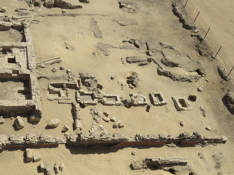
Figure 7. Tank area (center) and south eastern zone (top), with adjacent portions of the thoroughfare (bottom) and rectangular building (left), as they appeared after cleaning in 2018, looking east.
The area to the east of the tanks, forming the south east zone of the southern archaeological area, is very poorly preserved (see fig. 7). It retains traces of mud packing typically associated with paved flooring, short sections of mud brick walls and is crossed by water-supply pipes fed by the well in the Church of St. Shenoute. These pipes and others feeding the south rooms of the rectangular building pass through the passage or alley that lies between the rectangular building and a series of four rooms to the east (fig. 8). The original plaster floors of the passage/alley and rooms were, like that of the rectangular building’s courtyard, replaced with limestone paving. Unlike the other features of the southern archaeological area, the four rooms are of mud brick construction. The channel, cistern, and storage installations to the east of the four rooms, as well as the crushing basins at the eastern margin of the southern archaeological area, are late additions. One of the granite crushing basins is likely to have been moved from the food processing complex in the western archaeological area.[7]
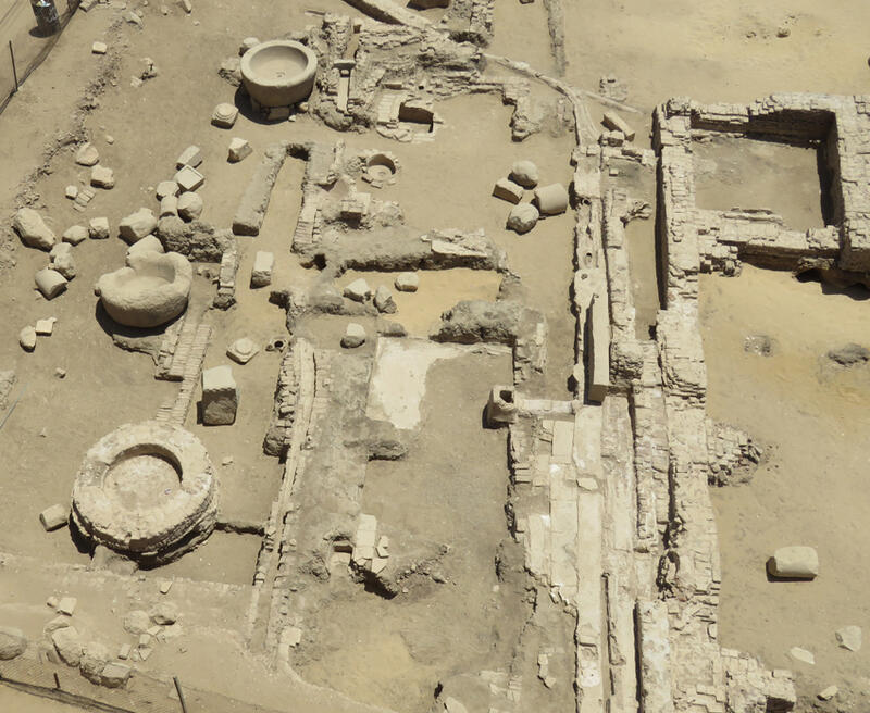
Figure 8. North eastern zone of the southern archaeological area with water pipes and passage/alley (right), four small rooms (center), water channel and crushing basins (left) as they appeared after cleaning in 2018, looking south. The south east corner of the rectangular building is on the far right.
The exact date of the abandonment of monastic activities within the southern archaeological area is uncertain, but it is likely to have taken place sometime in the medieval period. Sketches and photographs by modern visitors to the monastery show that the buildings outside the church had been reduced to huge mounds of rubble, which were still in place at the beginning of the twentieth century.[8] Some of the latest deposits visible in the exposed profiles on the west and north sides of the perimeter of the southern archaeological area contain discarded pottery, food waste, and a few objects dating to the late nineteenth and early twentieth centuries that are perhaps from the houses within the church. Later layers consist of a surface with post-holes and evidence for modern remodeling associated with the repopulatedmonastery.[9]
[1] L. Blanke, The Archaeology of Egyptian Monasticism: Settlement, Economy, and Daily Life of the White Monastery Federation, PhD. Thesis, Faculty of Humanities, University of Copenhagen, 2014. Now published as: L. Blanke, An Archaeology of Egyptian Monasticism: Settlement, Economy and Daily Life at the White Monastery Federation, Yale Egyptological Publications 2, New Haven: Yale University Press, 2018, see especially pages 94-102 for this area.
[2] P. Grossmann, D. Brooks Hedstrom, M. Abdal-Rassul, and E. S. Bolman, “The Excavation in the Monastery of Apa Shenoute (Dayr Anba Shinuda) at Suhag, with an Appendix on Documentary Photography at the Monasteries of Anba Shinuda and Anba Bishoi, Suhag,” Dumbarton Oaks Papers 58 (2004), 374–378, fig. A; P. Grossmann, D. L. Brooks Hedstrom, S. M. M. Osman, H.-C. Noeske, M. A. abd al-Rahim, T. Said Abd al-Fatah, M. Abd al-Mugdi, and J. Wolfgang, “Second Report on the Excavation in the Monastery of Apa Shenute (Dayr Anba Shinuda) at Suhag,” Dumbarton Oaks Papers 63 (2009), 178–186, figs. 10–20.
[3] For these areas and the geophysical survey, see: D. L. Brooks Hedstrom and E. S. Bolman, “The White Monastery Federation Project, Survey and Mapping at the Monastery of Apa Shenoute (Dayr al-Anba Shinuda), Sohag, 2005–2007,” Dumbarton Oaks Papers 65–66 (2011–2012), 1–32.
[4] Blanke, Archaeology, 94, 96, figs. 44–45. This area was interpreted by Peter Grossmann and colleagues as a toilet block. See Grossmann et al., “Excavation,” 374; Grossmann et al., “Second Report,” figs. 10–13.
[5] Blanke, Archaeology, 96–98, fig. 46. See also Grossmann et al., “Excavation,” 374–375; Grossmann et al., “Second Report,” 178–184, figs. 10–18.
[6] Blanke, Archaeology, 98–99, 102, fig. 47. See also Grossmann et al., “Excavation,” 374; Grossmann et al., “Second Report,” figs. 12–13.
[7] Blanke, Archaeology, 99-101.
[8] Blanke, Archaeology, cover and fig. 8. U. Monneret de Villard, Les couvents près de Sohâg (Deyr el-Abiaḍ et Deyr el-Aḥmar), Volume 1, Milan: Tipografia Pontificia e Arcivescovile S. Giuseppe, 1925, pls. 5-7.
[9] Blanke, Archaeology, 102.