Abu Ziyar and Tundaba Remains
By John Coleman Darnell with Deborah Darnell 1
The First Intermediate Period—War in the Sand and the rise of Thebes
After the collapse of the Old Kingdom, while the Heracleopolitan successor state languidly listened to the eloquent pleas of peasant farmers, Upper Egyptian governors, while nominally acknowledging northern suzerainty, engaged in more brawny and bellicose pursuits. The conflicts between increasingly pugnacious and grandiloquent southern rulers quickly spread into the Western Desert.
The shortest route between the Upper Egyptian Nile and the Red Sea leaves the Nile at the Qena Bend, as does the shortest route to the great southern oases Kharga and Dakhla.2 Thebes, which alone could directly control from a single center these best tracks through the Eastern and Western Deserts, rose from an Old Kingdom backwater to the become the nursery of empire. An inscription of the Coptite nomarch Tjauti at the Gebel Tjauti site states that an enemy nomarch, apparently the governor of Thebes, had “annexed the escarpment;” Tjauti further records that he opened a new route across the bend, an ultimately unsuccessful Heracleopolitan countermeasure.3 Just as Horus Scorpion appears to have employed the same route to outflank Naqada, so Thebes made use of the road in the reverse, swinging west of the important Coptite nome, avoiding any conflict with any Heracleopolitan troops in the area, and probably descending on the northern forces in the region of Abydos. Exploiting the benefits of her location and the desert-war skills of her Nubian allies,4 Thebes waged a war of maneuver by specialized forces in a marginal area, allowing for economy of force and indirectness of approach.5

Although the main northern routes of the Theban Western Desert preserve ample evidence of early contacts between the Nile and Kharga Oasis,6 official development of a route between the Thebaid and the southern oases first occurred during the early Middle Kingdom. Having established Theban domination of the Egyptian Nile Valley, Monthuhotep II turned his attention to securing routes through the Eastern and Western Deserts, the latter providing access to the oases, and connecting with desert routes south into Nubia. During the Middle Kingdom, the so-called Girga Road appears to have become the major artery between the southern oases and the Nile (Figure 1).
The Middle Kingdom—the Rise of Kharga and the Girga Road
Even before the final subjugation of First Intermediate Period criminality in the oases, Monthuhotep II appears to have altered the economic status of the oases and desert regions, with considerable implications for the use of desert routes. The early Middle Kingdom “Ballas Inscription,” an early “royal novel” probably dating from the reign of Monthuhotep II, refers to the annexation of Lower Nubia and an oasis area to newly imperial Thebes (Figure 2):7
x+5: … […] … Wawat and the o[asis …]
x+6: … […]the trouble-makers(?) therein.
To Upper Egypt did (I) attach it.
 There is no king for whom they worked during the former reigns [of the
ancestors(?)] …
[…] in as much as he loves me (?) …
x+12: {…] Wawat and the oasis—
That (I) attached them to Upper Egypt
was after (I) drove out the reb[elious ones(?)…]
Although earlier Theban rulers had received inw-income from desert regions,8 the ruler who speaks in the Ballas Inscription claims that Lower Nubia and first made obligatory b3k-payments into the Egyptian economy during his reign.9 In expanding into Wawat, chiefly in order to secure Theban control of the military recruiting grounds of Lower Nubia, the Thebans appear to have employed the Darb Gallaba and Darb Bitan routes of the Western Desert, leading through the oases of Kurkur and Dunqul on the Sinn el-Kaddab.10
In spite of the Eleventh Dynasty rulers’ efforts, the Kharga and Dakhla region remained outside the jurisdiction of the Theban constabulary. The early Middle Kingdom policeman Kay traveled to the oasis region to bring back a fugitive (rebel leader?),11 and the Twelfth Dynasty policeman Beb “policed for the king in all the deserts,”12 both probably traveling Theban routes to the west. The Steward Dediku explicitly states on his stela that he set out from Thebes to secure the land of the oasians.13
 The Ballas Inscription of Monthuhotep II (after Fischer, Inscriptions from the Coptite Nome). Figure 3, Aerial view of the site of Abu Ziyar (aerial photography kites and gondola, with accoutrements, constructed by Raoul Fosset); the reddish area in the upper portion of the image reveals the density of the sherd concentration.")
The fires of civil unrest, fueled in part by the mercenaries who flooded the ranks of the local armies during the First Intermediate Period,14 erupted during the reign of Amenemhat I. After the re-establishment of centralized control over the Nile Valley later in the same reign, the pharaonic state began construction of a physical basis for pharaonic hegemony in the Egyptian and Nubian deserts. In addition to building the great fortress complex along the Second Cataract in Nubia, and smaller outposts in the Eeastern15 and Western16 Delta, Middle Kingdom Egypt maintained many patrol routes and smaller installations in the Western Desert. Concentrations of hut emplacements and shelter areas along desert roads served as outposts for perambulating desert patrols; the consistent kits of pottery — ovoid jars of silt, small globular Marl A3 vessels, and hemispheric cups — associated with these huts reveal the presence of state-supplied patrolmen.17 The policemen and soldiers themselves are in evidence from their inscriptions in the Theban Western Desert.18
The well-monitored routes of the Western Desert were the economic arteries that tied Middle Kingdom Kharga to the Nilotic administration. Middle Kingdom governors of Dakhla continued to maintain desert routes,19 and Dakhla continued to serve as a base for expeditions toward the far southwest.20 Middle Kingdom inscriptions near Bahariya21 also suggest a use of the entire oasis ring route.
Abu Ziyar
An extensive Middle Kingdom supply depot, located approximately one-third the distance from the Nile Valley on the northern Girga Road to Kharga, is evidence of a new and previously unsuspected level of official sponsorship on routes between the Theban Nile Valley and the oases. The site, which we have named Abu Ziyar (Figure 3 and 4), appears originally to have comprised several hundred large Marl-C storage jars (zirjars) (Figure 5), of early Middle Kingdom shape,22 centered to the east of a rectangular, dry stone structure. The jars, from their fabric seemingly products of the area of Lisht,23 appear to have been dispatched from the Nile Valley as provisions for a large expedition — perhaps the official “opening” of Kharga to Middle Kingdom activity.

Aside from the Marl-C storage jars, most of the other ceramic remains at the site are of Nilotic manufacture, with a few of oasis fabrics. The enormous number of Marl C zirs is augmented by other vessels of the fabric, the most numerous of these additional forms being jars with corrugated necks (Figure 6a).
 Reconstructed Marl-C storage jar (zir) from the site of Abu Ziyar. Figure 6, Two early Middle Kingdom bowls and a bread mould from Abu Ziyar.")
Ceramic forms attested at Abu Ziyar include numerous portions of thin silt hemispherical cups, carinated and ring-based bowls, small bowls with rilling beneath the rims (Nile B2-C fabric, Figure 6b, a form and decoration appearing — like the zirs themselves, after the move to Itjy-Tawy),24 and other vessels of Middle Kingdom date. The presence of numerous fragments of bread moulds indicates food preparation at the site (Figure 6). A very few fragments of animal bones appeared within an ash layer on the floor of the rectangular structure are evidence that fastidious food preparation took place in the structure.
The best parallels for the entire corpus are early Middle Kingdom, and more specifically the corpus appears to date to the reign of Sesostris I. Remains of mud seals — including document sealings — support the Twelfth Dynasty date of the outpost, and provide evidence for careful administrative control of the activities at the site (Figure 7).25 The closest parallels to the Abu Ziyar site are expedition bases such as the Gebel el-Asr quarry site,26 revealing an application of official expedition patronage and outfitting to the control and provisioning of a route connecting the Thebaid to the southern oases.
 Examples of the four types of seal impressions from Abu Ziyar. Figure 8 (photo on right) O. Abu Ziyar 2, a work foreman’s “calling card.”")
Most of the sealing types are oval (perhaps sealing small containers) and long, ingot-like (sealing papyri) forms. The “treasury” sealing (Type IV) appears to have been affixed to a cloth wrapping around a large ceramic vessel (probably a zir). All certain document seal fragments show evidence of secondary firing, and several were within a layer of ash directly atop the floor of the structure (Square B4/C4, Level 3C). Impressions on the backs of the ingot-like sealings are consistent with papyrus; carbonized, fibrous remains in the lower, compacted ash of the structure’s floor (Level 4) are consistent with burned papyrus.
In addition to the sealings, Abu Ziyar has also produced several ostraca, ink on stone and pottery, and incised stone. Ostracon Abu Ziyar 2, black ink in a good Middle Kingdom bureaucratic hieratic hand on a limestone pebble, refers to a work foreman (ṯsw)27 and his crew of apparently 300 men, revealing the use of tax laborers and overseers from the world of government managed work crews28 at the high desert outpost. Perhaps involved in setting up Abu Ziyar, the foreman and his crew may also have been en route to an outpost in one of the oases, perhaps Gebel Ghueita in Kharga Oasis, where archaeological remains indicate a Middle Kingdom settlement of no mean size.29
O. Abu Ziyar 2 (Figure 8)
The brief text comprises three lines of horizontal hieratic, palaeographically of good Middle Kingdom form, adeptly written in a bureaucratic hand (as opposed to the more classic literary and epistolographic hand in which the fragmentary pottery ostracon was written)
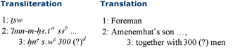
- a The initial sign is a slightly thick version of a reed leaf (Gardiner M17),30 followed by an abbreviated mn over n.31 The m-owl is also abbreviated, and the final stroke of
 has no clear representation of the t phonetic compliment — note the identical orthography of the name Amenemhat in P. Brooklyn 35.1446, recto 8a.32
 - b Following the personal name is essentially a stroke above a horizontal line, an abbreviated form of the filiation s3 reasonably well attested for the Middle Kingdom.33
- c Although the upper horizontal is slightly sinuous, the word following the preposition
 is probably a writing of s.w, “men.”
 - d A reading of 100, 200, or 300 is also conceivable.
The man whose father we know to have been Amenemhat, was a ṯsw. Not only does ṯsw seem to be a temporary title,34 it also belongs to the world of tax work, corvée labor, not to the command structure of such undertakings as quarry expeditions.35 The ṯsw-foreman is precisely the sort of ṯsw who would have simply people — men as here — under his authority.
 A cutting through the ash filling the central pit in Square D4. Figure 10 (inset photo), Section of four excavation squares at Abu Ziyar, including clearance of the rectangular dry-stone structure.")
The site of Abu Ziyar has revealed pits used in the preparation of charcoal, and for the burning of charcoal in what may have been large-scale cooking to provision the troops and work crews who may have stopped at the site (Figure 9). C-14 analysis of the charcoal in the shallower pit along the north edge of square D4 has yielded a date consistent with the beginning of the Middle Kingdom — radiocarbon dating: conventional 14C age: 3605 +/- 48BP (13C measured of 25.047% vs PDB); calibrated 14C date: 2026 BC : 1904 BC 68.2% (1 sigma) (IFAO Sample 234). Clearance of several squares at the site indicates that an initial period of intensive use was followed by a short abandonment, with sand accumulation of several centimeters. A second period of intensive use, also during the first half of the Twelfth Dynasty, saw the construction of subsidiary walls to the initial rectangular structure (Figure 10).
 Rectangular dry-stone structure at Abu Ziyar, after clearance. Figure 12, Ceramic material from Middle Kingdom occupation of the rectangular dry-stone structure at Abu Ziyar. C and D are made in a fine oasis fabric.")
The drystone structure (Figure 11), oriented roughly north-south, was an “industrial” area, a place of much burning, use of upside-down Marl-C storage jars as tables, and the cutting down of broken pots and cups into small, spatula-shaped objects (Figure 12). The structure also contained two complete cups of oasis fabric (imitation of Nile silt), one with faint interior incising, the other an odd variation on the spouted bowls so common in the oases, with a small knob of clay where one would expect a spout (Figure 12). The purpose of these “spoons” is revealed in an elaborate piece of Middle Kingdom “domestic” technology — the kanoon, discovered during the 2005-2006 field season (Figure 13). This object was a large silt “offering stand” of a type attested from the early Middle Kingdom through the Second Intermediate Period.36 Within the Abu Ziyâr “stand” was placed a large, silt bowl, the bottom of which had been cut out; inside the bowl, perched above and protruding down slightly through the bowl’s open bottom, was a silt hemispherical cup, filled to the rim with fine, white ash. The space between the lower portion of the cup and the edges of the bowl filled with the small, spoon-like objects cut down from other cups and bowls so prevalent at Abu Ziyâr. The “chinking sherds,” in conjunction with the cut out bowl bottom, appear to have allowed for the cup to be positioned in such a way that the top of the cup did not protrude above the upper rim of the “stand,” and the sides of the cup did not touch the bowl directly. The top of the bowl, between the edge of the cup and the outer edge of the brazier, was smeared with a combination of mud and dung,37 which had hardened through heating.

The ceramic ensemble appears to have been devised as a way of dissipating the heat of a fire within the central cup, so as to prevent a constant heat within the cup from ultimately cracking the large brazier. Rare examples with evidence of burning have been discovered,38 but the Abu Ziyâr brazier is the first to reveal the unexpectedly complex manner in which the object was used.39
The Second Intermediate Period and the Early New Kingdom — Retrenchment, and the Wrath of Thebes
Through the course of the Middle Kingdom the routes of the Western Desert appear to have achieved a self-sufficient status, and by the time of the Thirteenth Dynasty the great depot at Abu Ziyar was no longer maintained, having fulfilled its function in the development of the Western Desert roads and the opening of Kharga Oasis. An often-assumed Hyksos control of the deserts40 finds little support from epigraphic or archaeological remains,41 and Kerma does not appear to have been in firm control of the desert roads to its north, although a Nubian razzia reached at least as far north as Elkab.42 During the early Second Intermediate Period Thebes appears as well not to have maintained any major presence on the routes of the Western Desert. In Kharga, occupation continued at Gebel Ghueita, with local Middle Kingdom styles persisting; Theban styles also appeared in Kharga, these becoming more prevalent as the Seventeenth Dynasty progressed. Within the Qena Bend, however, Theban activity never ceased throughout the Seventeenth Dynasty, and grew exponentially during the latter part of the dynasty at the Wadi el-Hôl, Gebel Qarn el-Gir, and Gebel Antef sites. By the late Seventeenth Dynasty, Thebes again controlled the northern Girga route, ultimately allowing Kamose to capture a Hyksos messenger.
Tundaba
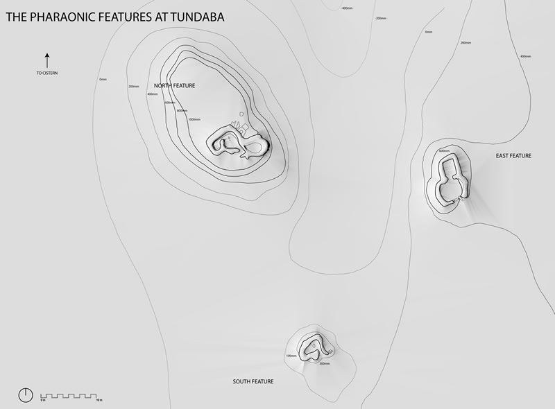
Economically, Mothuhotep II’s integration of the oases into the pharaonic economy, and his successors’ exertions in opening the Girga Road and developing Kharga Oasis, bore fruit by the end of the Second Intermediate Period. Tundaba, a desert outpost at the midpoint of the main northern route between the Nile and the northeastern wells of Kharga Oasis (Figure 1),43 provides concrete evidence for the success of Thebes’ attempts at controlling the routes of the Western Desert. The most visible remains at Tundaba are three dry-stone constructions, and a cistern (Figure 14). During the late Seventeenth Dynasty, people using Theban pottery, with some oasis imports, occupied two low hills at the site. Shortly thereafter they constructed two partially subterranean structures with dry stonewalls above ground, apparently originally roofed by tents. This mode of construction maximizes the heights of the walls from within while minimizing the profile of the structure from outside. These structures, and a small cooking area to the south (at which ostrich eggs were cooked in large quantities), appear to have housed a small garrison to guard the strategic desert road.
The cistern at Tundaba, a thus far unique example of deep pharaonic hydrologic engineering on the high desert plateau, possesses an overall bipartite construction (Figure 15). The roughly circular upper portion — approximately 7 meters in diameter and 4.5 meters in depth — is cut into the playa alluvium, with platforms to the north, a ramp and stairs to the east, and a longer, spiral staircase descending the south and west walls (Figure 16). The second portion of the well is a shaft descending through the limestone bedrock. The final depth of the well is 28 meters and 35 centimeters. The closest parallels to the Tundaba cistern are wells at the city of Amarna,44 grand puit at Deir el-Medina, and an unexcavated well emplacement in the Eastern Desert’s Wadi Gasus.45 The lower shaft, with the slight shift in orientation and the hand and foot holds is remarkably similar to the tomb shaft 41 in the “Vallée du Puits.”46
, topographical plan of the site of Tundaba, showing the three drystone structures. Photo right, aerial photograph of north and south features with caravan tracks visible in the upper portion of the image.")
Trenches through the ring of ancient radîm surrounding the well have revealed the somewhat surprising history of the construction of the final version of the bîr. Unexpectedly, the first and most abundant material deposited in the radîm, during the excavation of the Second Intermediate Period/early New Kingdom bîr, was sand (Figure 17). Atop this thick layer of sand the original diggers of the well deposited layers of playa earth, limestone rocks and chips, more earth and limestone, and marl. The great quantity of sand in the lowest part of the radîm suggests that the ancient well engineers first cleared some preexisting, sand filled depression of no mean size, then enlarged the depression, cutting into the ancient playa earth, while constructing the spiral stairs of the bîr. The limestone deposited within the radîm, ranging from large boulders to small chips, is consistent with the cutting of the shafts proper, beneath the stairway; the marl, relatively meager in quantity, is evidence of the lowest level of the final excavation of the shaft.
 Two sections of the Tundaba cistern after clearance. Figure 16, Spiral staircase in the upper portion of the Tundaba cistern.")
A number of pharaonic sherds lay atop the original radîm (Level 8), and others were imbedded within the surface of the rim of the bîr. The sherds atop the radîm were of late Second Intermediate Period to early Eighteenth Dynasty in date. In all cases, sherds imbedded in the water-deposited surface beneath the radîm were exclusively of Second Intermediate Period to mid-Eighteenth Dynasty date, corresponding in type to pottery atop the radîm. No post-Eighteenth Dynasty pottery appeared below the hardpacked sand representing the initial filling of the bîr, suggesting the bîr may have been abandoned by the Ramesside Period. Two sherds of pharaonic date were also found at the very bottom of the well. This ceramic evidence indicates a Second Intermediate Period to early New Kingdom date for the final form of the well, agreeing with material from the associated dry stone structures at Tundaba.
 Some Middle Kingdom pottery near the well may relate to an earlier bir at the site, perhaps — like Abu Ziyar — part of the Middle Kingdom supply system on the road. An enlargement of the cistern at the end of the Seventeenth Dynasty would be a very early example of New Kingdom interest in developing water sources for desert activities, for which one may compare the activity of Sety I in the Wadi Mia, and that of Sety I and Ramesses II in the Wadi Alaqi;47 Merneptah also claims to have been energetic in reopening neglected wells, putting them “in working order for messengers.”48
O. Tundaba (Figure 18)
By the dawn of the Eigtheenth Dynasty, if not earlier, the outpost at Tundaba began to pay for itself, delivering income into Egypt’s administrative coffers.

An ostracon from Tundaba, palaeographically of early Eighteenth Dynasty date, records the calculation of an obligatory payment to the administration (š3y.t),49 probably duty paid as well-tax. The ostracon — a fragment of an oasis fabric jar, broken in two pieces — lay beneath a large stone in the northeast corner of the front (south) room of the East Feature at Tundaba. The pottery on which it is written and the nature of the text indicate that this small computation was made at Tundaba. The fabric, the vessel shape, and the palaeography of the text all consistently support an early Eighteenth Dynasty date for the ostracon.

- a This appears to be the liquid measurement hnw.50 Dots follow the one-word headings of the first two lines, setting these off from the following numbers.
- b The š3-plant was followed by an aleph-vulture, the only considerably damaged sign on the ostracon; the following group appears be t over plural strokes. The final signs represent n over seated man, and a dot signaling the beginning of the calculation. The term š3y.t designates “what is destined” as payment of ḥtr assessments,51 and may more specifically indicate “une redevance dont le montant était fixé par avance, conformément à une tradition (i.e., sans considération des potentialités productives réelles du secteur économique devant la fournir)”.52
- c The addition on the ostracon is peculiar. The first three numbers apparently represent three independent calculations of the units that will eventually yield the total of the duty. Nevertheless, following the somewhat premature label “total,” only the final two amounts (25 and 188) are added, and the initial amount (37) is tacked on afterwards.
A well tax is known from the time of the Old Kingdom,53 and for the New Kingdom is well in evidence in the Turin Taxation Papyrus.54 According to the Turin document, each controller (rwḏw)55 of a well in the “southern and northern oases” oversaw the collection and delivery of some payment, perhaps š3y.t, that formed part of the ḥtr-tax of the wells. Already the policeman Kay, bringing law and order to the oases in the early Middle Kingdom (see above), was himself a rwḏw-agent, perhaps also an economic agent of Monthuhotep’s then new economic approach to the oases.
 Inscribed mud-seals from the East Feature at Tundaba. Figure 20, Selection of ceramic forms from the features at Tundaba.")
Mud seals at Tundaba provide further evidence for the functioning of the Seventeenth/Eighteenth Dynasty administration in the Western Desert. One seal bears the prenomen of Thutmosis I (Figure 19a)56 ; others have images of Bes and Taweret, and walking wsr-signs, a never-common version of the sign, appearing first in late Old Kingdom hieratic, and occasionally thereafter, as in the name of Ramesses II in the mortuary temple of Sety I at Qurna, but most commonly in the names of the Fifteenth Dynasty Hyksos rulers.57 The ceramic material at the site is almost evenly divided between Nile Valley and oasis fabrics, and specific Theban ceramic forms abound. Typical late Second Intermediate Period forms in Nile B1/B2 include small jars with incised lines on the necks (Figure 20b),58 “wine jars” (Figure 20c), and cooking bowls (Figure 20d). One Marl A2 vessel from the East Feature is a sharply carinated jar with a pronouncedly squat profile, bearing monochrome decoration consisting of groups of vertical lines without any diagonal intersecting lines (Figure 20e), a common vessel type in the late Seventeenth Dynasty and early Eighteenth Dynasty.59 Beer jars with simple, everted rims appear in both Nile B2 and in oasis imitation silt (Figure 20d). Imported fabrics are also present, including Syro-Palestinian fabrics.
Together, the Abu Ziyar and Tundaba sites reveal the evolution of pharaonic activity on the Western Desert plateau from the early Middle Kingdom through the early New Kingdom. A major focus of this activity was Kharga Oasis, where one of the important pharaonic centers of the Middle Kingdom developed at Gebel Ghueita.
Notes
- 1. A preliminary presentation of the work at Abu Ziyar and Tundaba, based in part on season reports by J.C. Darnell and D. Darnell. An update and expansion of the section on the Abu Ziyar ceramics will appear once D. Darnell has had an opportunity to examine the ceramic remains from the most recent period of work at the site.
- 2. J.C. Darnell, et al., The Theban Desert Road Survey I: The Rock Inscriptions of Gebel Tjauti in the Theban Western Desert, Part 1, and the Rock Inscriptions of the Wadi el Hôl, Part 1, OIP 119 (Chicago, 2002), pp. 35-36; idem., “Opening the Narrow Doors of the Desert: Discoveries of the Theban Desert Road Survey,” R. Friedman, ed., Egypt and Nubia — Gifts of the Desert (London, 2002), pp. 132-155.
- 3. J. C. Darnell, Theban Desert Road Survey I, pp. 30-37.
- 4. On whom see H.G. Fischer, “The Nubian Mercenaries of Gebelein during the First Intermediate Period’, Kush, 9 (1961): 44-80.
- 5. For these concepts see B.H. Liddel Hart, Strategy, 2nd ed. (New York, 1991).
- 6. J.C. Darnell, et al., Theban Desert Road Survey I, pp. 28-29 and 43-46; idem., in Friedman, ed., Egypt and Nubia, pp. 147-149; D. Darnell, in ibid., pp. 165-169.
- 7. H.G. Fischer, Inscriptions from the Coptite Nome, Dynasties VI-XI, Analecta Orientalia 40 (Rome, 1964), pp. 112-113; J.C. Darnell, The Birth of Victorious Thebes, forthcoming.
- 8. A.M. Blackman, “The Stela of Thethi, Brit. Mus. No. 614,” JEA 17 (1931): 55-61 and pl. 8, l. 6; J.J. Clère and J. Vandier, Textes de la première période intermédiaire et de la Xième Dynastie (Brussels, 1948), p. 15.
- 9. E. Bleiberg, “The Redistributive Economy in New Kingdom Egypt: An Examination of B3kw(t),” JARCE (1988): 25; J.C. Moreno Garcia, “Acquisition de serfs durant la première période intermédiare,” RdE, 51 (2000): 129-130 n. 41; S.T. Smith, Wretched Kush (London, 2003), pp. 182-183.
- 10. J.C. Darnell, “The Route of Eleventh Dynasty Expansion into Nubia, an Interpretation Based on the Rock Inscriptions of Tjehemau at Abisko,” ZÄS 131 (2004): 23-37; compare also the title in a rock inscription at Kumma: “prince and count of the (narrow) door (of the desert) of Upper Egypt, of Thebes and Nubia” — G.A. Reisner, D. Dunham, and J.M.A. Janssen, Semna Kumma (Boston, 1960), pl. 100G and p. 156; W.A. Ward, Index of Egyptian Administrative and Religious Titles of the Middle Kingdom (Beirut, 1982), p. 101, no. 844a.
- 11. R. Anthes, “Eine Polizeistreife des Mittleren Reiches in die westliche Oase,” ZÄS 65 (1930): pl. 7, ll. 4-6; R.E. Freed, “Stela Workshops of Early Dynasty 12,” in P. Manuelian (ed.), Studies in Honor of William Kelly Simpson 1 (Boston, 1996), p. 304.
- 12. P.A.A. Boeser, Beschreibung der aegyptischen Sammlung der Niderlandischen Reichsmuseum der Altertümer in Leiden II part 1, Stelen (The Hague, 1909), p. 5 and pl. 10, ll. 7-8; G. Andreu, “Les titres de policiers formés sur la racine schena,” CRIPEL 9 (1987): 19-20.
- 13. H. Schäfer, “Ein Zug nach der grossen Oase unter Sesostris I,” ZÄS 42 (1905): 124-28.
- 14. J.C. Darnell, “The Rock Inscriptions of Tjehemau at Abisko,” ZÄS 130 (2003): 31-48; idem, ZÄS 131 (2004): 23-37.
- 15. S. Quirke, “Frontier or Border? The Northeast Delta in Middle Kingdom Texts,” in The Archaeology, Geography and History of the Egyptian Delta in Pharaonic Times (Oxford, 1989), pp. 261-274.
- 16. A. Fakhry, “Wâdi-el-Natrûn,” ASAE 40 (1940): 837-848.
- 17. J.C. Darnell and D. Darnell, “Theban Desert Road Survey,” in Oriental Institute Annual Report 1996-1997 (Chicago, 1997), pp. 72-73; cf. M. Chartier-Raymond, et al., “Les Sites miniers pharaoniques du Sud-Sinaï, Quelques notes et observations de terrain,” CRIPEL 16 (1994): 61-64; D. Dunham, ed., Second Cataract Forts II: Uronarti, Shalfak, Mirgissa (Boston, 1967), pp. 141-142.
- 18. J. C. Darnell, et al., Theban Desert Road Survey I, pp. 56-65, 70, 73-74, 123-124, 137-138, 141, and 143; idem., in Freidman, ed., Egypt and Nubia, p. 145.
- 19. M. Baud, F. Colin, and P. Tallet, “Les gouverneurs de l’oasis de Dakhla au Moyen Empire,” BIFAO 99 (1999): 1-19; for Middle Kingdom use of the Darb el-Ghubari between Dakhla and Kharga, see J. Osing, “Notizen zu den Oasen Charga und Dachla,” GM 92 (1986): 81-82; H. Winkler Winkler, Rock-Drawings of Southern Upper Egypt 1 (London, 1938), p. 12 and pl. 8, 1.
- 20. G. Burkard, “An Inscription in the Dakhla Region,” Sahara 9 (1997): 152-153, with corrections in Darnell, et al., Theban Desert Road Survey I, p. 73.
- 21. G. Castel and P. Tallet, “Les inscriptions d’El-Harra, oasis de Bahareya,” BIFAO 101 (2001): 99-136.
- 22. Compare B. Bader, Tell el-Daba XIII. Typologie und Chronologie der Mergel C-Ton Keramik (Vienna, 2001), pp. 155-160.
- 23. Do. Arnold, “The Pottery,” in Di. Arnold, The Pyramid of Senwosret I, South Cemeteries of Lisht 1 (New York, 1988), pp. 112-116.
- 24. Compare Do. Arnold, in Arnold, The Pyramid of Senwosret I, p. 111, fig. 55a, no. 8.
- 25. Compare B. Gratien, “Scellements et contrescellements au Moyen Empire en Nubie, L’apport de Mirgissa,” CRIPEL 22 (2001): 47-69; von Pilgrim, “The Practice of Sealing in the Administration of the First Intermediate period and the Middle Kingdom,” in ibid., pp. 161-172.
- 26. I. Shaw, “The 1997 Survey of the Ancient Quarrying Site of Gebel el-Asr (‘The Chephren Diorite Quarries’) in the Toshka Region,” ASAE 74 (1999): 63-67; idem, and E. Bloxam, “Survey and Excavations at the Ancient Pharaonic Gneiss Quarrying Site of Gebel El-Asr, Lower Nubia,” Sudan and Nubia 3 (1999): 13-20; J.C. Darnell and C. Manassa, Inscribed Material from the Gebel el-Asr Quarries, forthcoming.
- 27. Quirke, Titles and Bureaux, pp. 83 and 102.
- 28. Compare W.K. Simpson, Papyrus Reisner 1 (Boston, 1963), p. 38 et passim.
- 29. D. Darnell, in Freidman, ed., Egypt and Nubia, pp. 172-173.
- 30. Möller, Paläographie 1, p. 27.
- 31. Compare Simpson, Reisner 1, p. 103.
- 32. W.C. Hayes, A Papyrus of the Late Middle Kingdom in the Brooklyn Museum (Brooklyn, 1955), pl. 1.
- 33. See W.K. Simpson, Papyrus Reisner III (Boston, 1969), pp. 12-13; J. C. Darnell, Theban Desert Road Survey 1, p. 71.
- 34. As S. Quirke, Titles and Bureaux of Egypt 1850-1700 BC (London, 2004), pp. 83 and 102, notes, discussing the title ṯsw — “it seems more a transiently held position than a permanent designation for an individual” (ibid., p. 102).
- 35. Compare K.-J. Seyfried, Beiträge zu den Expeditionen des Mittleren Reiches in die Ost- Wüste, HÄB 15 (Hildesheim, 1981), pp. 115-131, 188-219, and 259-269. A ṯsw appears in at least one of the Wadi el-Hudi inscriptions (ibid., p. 77; A.I. Sadek, The Amethyst Mining Inscriptions of Wadi El-Hudi 1: Text [Warminster, 1980], pp. 56 and 74), but in a short inscription that does not clarify his function; like some of the hunters and overseers of hounds, he may have been at the site of some mission other than that of the expeditions.
- 36. Compare the comments on the form in Bader, Mergel C-Ton, pp. 60-62.
- 37. As identified by University of Groningen Palaeobotanist Jeroen van Rooij in the expedition’s magazine in Gurna (June 21, 2006). The dung contained digested botanical remains (no longer specifically identifiable), and small pebbles (+/- 1mm in size), suggesting that the mud portion of the compound was — as one would expect — collected on site, the pebbles being desert wash into the Abu Ziyâr pan.
- 38. See the rather small example in C. von Pilgrim, Elephantine XVIII: Untersuchungen in der Stadt des Mittleren Reiches und der Zweiten Zwischenzeit, AV 91 (Mainz, 1996), pp. 338-339, fig. 150h (cited in Bader, Mergel; C-Ton, p. 67 n. 365).
- 39. Compare Bader, Mergel C-Ton, p. 62: “Möglicherweise verbrannte(?) man darin Opfergaben von grösserem Format, da kleinere Gegenstände durch die Öffnung in der Mitte in den Fuss gefallen wären oder — wahrscheinlicher — man stellte eine Schale o.ä. auf bzw. In die Fussschale.”
- 40. As in J. Bourriau, “Some Archaeological Notes on the Kamose Texts,” in A. Leahy and J. Tait, eds., Studies on Ancient Egypt in Honour of H.S. Smith (London, 1999), pp. 43-48.
- 41. K.S.B. Ryholt, The Political Situation in Egypt during the Second Intermediate Period (Copenhagen, 1997), pp. 140-142 and 327; J.C. Darnell, Darnell, “Articular Km.t/Kmy and Partitive KHME,” Enchoria, 17 (1990): 72; M. Baud, “Balat/’Ayn-Asil, oasis de Dakhla: la ville de la Deuxième Période Intermédiaire,” BIFAO 97 (1997): 27-28.
- 42. W.V. Davies, “Kush in Egypt: A New Historical Inscription,” Sudan and Nubia 7 (2003): 52-54; idem, “Sobeknakht of Elkab and the Coming of Kush,” Egyptian Archaeology 23 (2003): 3-6.
- 43. J. C. Darnell, et al., Theban Desert Road Survey I, p. 45; D. Darnell, in R. Friedman, ed., Egypt and Nubia, pp. 169-172; J. C. Darnell, in ibid., pp. 147-149.
- 44. B.J. Kemp, and S. Garfi, A Survey of the Ancient City of El-‘Amarna (London, 1993), p.69 and Sheet 6; A. Galal, “Report on the 1987 Excavations: a Large Well beside Building Q48.4,” in B.J. Kemp, ed., Amarna Reports 5 (London, 1989), pp. 1-14.
- 45. G. Schweinfurth, “Alte Baureste und hieroglyphische Inschriften im Uadi Gasus,” in Abhandlungen der Preußischen Akademie der Wissenschaften 1885 (Berlin, 1885), pp. 6-7.
- 46. L. Gabolde, H.I. Amer, and P. Ballet, “Une exploration de la «Vallée du Puits»: la tombe inachevée No 41,” BIFAO 91 (1991): 179-186.
- 47. For Wadi Mia see S. Schott, Kanais. Der Tempel Sethos I. im Wadi Mia, NAWG I phil.-hist. Klasse 4 (Göttingen, 1958); for the Wadi Allaqi see the Kouban Stela: M. Gabolde and G. Galliano, eds., Coptos: L’Égypte antique aux portes du desert (Lyon and Paris, 2000), p. 153, cat. no. 113; Kitchen, Ramesside Inscriptions 2, pp. 353-360; see also the bibliography in Kitchen, Ramesside Inscriptions. Translated and Annotated, Notes and Comments 2, p. 214; for an indication of the probable location see Piotrovsky, “The Early Dynasty Settlement of Khor Daoud and Wadi-Allaki. The Ancient Route of the Gold Mines,” in Fouilles en Nubie (Cairo, 1965), pp. 127-140.).
- 48. KRI IV 18, ll. 5-7. To the west of the Tundaba bîr, and outside the north feature, there is considerable ceramic evidence for a late Eighteenth Dynasty-early Ramesside Period presence at Tundaba. The Ramesside pottery may be related to activity by Sety I or Merneptah — or both — in clearing the Tundaba well.
- 49. D.A. Warburton, State and Economy in Ancient Egypt, OBO 151 (Fribourg and Göttingen, 1997), p. 281.
- 50. Compare the orthographies in P. Grandet, Catalogue des ostraca hiératiques non littéraires de Deîr El-Médînéh 8, DFIFAO 39 (Cairo, 2000), p. 124, no. 722.
- 51. See the overview in Warburton, State and Economy in Ancient Egypt, pp. 278-281.
- 52. P. Grandet, Le Papyrus Harris I (BM 9999) vol. 2, BdÉ 109/2 (Cairo, 1994), pp. 60-61.
- 53. R. Weill, Les Décrets royaux de l’Ancien Empire égyptien (Paris, 1912), pl. 3; H. Goedicke, Königliche Dokumente aus dem Alten Reich, Äg.Ab. 14 (Wiesbaden, 1967), p,72 n. 30, and fig. 5.
- 54. D. Warburton, State and Economy in Ancient Egypt: fiscal vocabulary of the New Kingdom (Freiburg, 1997), pp. 159-164.
- 55. D.B. Redford, The Wars in Syria and Palestine of Thutmose III (Leiden, 2003), p. 42 n. 252; J. Winand, “Les Décrets oraculaires pris en l’honneur d’Henouttaouy et de Maâtkarê (Xe et VIIe pylônes),” Karnak 11 (2003): 661 n. j; J.-M. Kruchten, “L’Évolution de la gestion dominiale sous le nouvel empire Égyptien,” in Lipinski, ed., State and Temple Economy in the Ancient Near East (Leuven, 1979), pp. 517-522.
- 56. This drawing is a corrected version of Darnell, in Friedman, ed., Egypt and Nubia, p. 148, fig. 20, which was based on a drawing done on site; further details emerged after the mud-seal was cleaned of adhering debris.
- 57. Compare H.G. Fischer, “The Evolution of Composite Hieroglyphs in Ancient Egypt,” Metropolitan Museum Journal 12 (1977): 17 n. 156; idem, Egyptian Studies 3 Varia Nova (New York, 1996), p. 188. Wsr-signs with a single leg appear on Middle Kingdom apotropaia — see Louvre AF6447 in Altenmüller, Die Apotropaia 1, p. 37 and vol. 2, pp. 103-104 (dated to the first half of the Twelfth Dynasty); Romano, Bes Image, p. 95.
- 58. For parallels, see Seiler, Tradition und Wandel, p. 152, Faltafel 7, no. 5
- 59. R. Holthoer, New Kingdom Pharaonic Sites: the Pottery (Copenhagen, 1977), pp. 136-143, particularly pl. 31 no. 185/122:3
For abbreviations of periodicals, see www.ifao.egnet.net/c?f=/doc/PubEnLigne/Monographies/Abreviations.pdf.