Tell Edfu Project
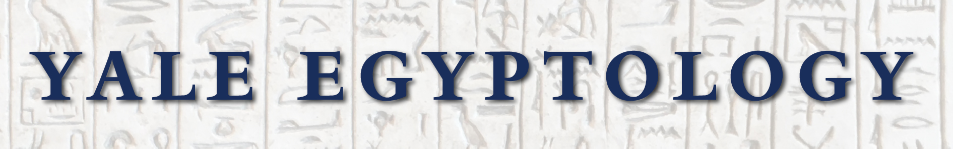
The temple of Edfu - view from the tell towards the east. ©Tell Edfu Project
About the Tell Edfu Project
The remains of the ancient town of Edfu are situated on the west bank of the Nile, halfway between Luxor and Aswan. Two toponyms, Behedet and Djeba, are attested for Edfu for the Pharaonic Period. There is evidence for the former from the Old Kingdom onwards. Djeba, however, has its earliest attestation in the Middle Kingdom. This is probably also the origin of the Coptic name, which is Etbo. In the Ptolemaic Period, the town was called Apollinopolis Magna.
In ancient times, Edfu was the capital of the 2nd Upper Egyptian nome and thus played an important role within the region. The floodplain is quite wide in this part of the Nile Valley, approximately 6.7 km from the western desert edge across to the eastern one. The upstream limits of the 2nd Upper Egyptian nome lay about 13 km north of Edfu, while the downstream border was situated 15 km to the south. Several routes connect Edfu via the Eastern Desert to the Red Sea coast. Additional desert roads lead from Edfu through the Western Desert to the oasis of Kharga. These connections made Edfu a strategically important starting and/or end point for trade and mining expeditions.
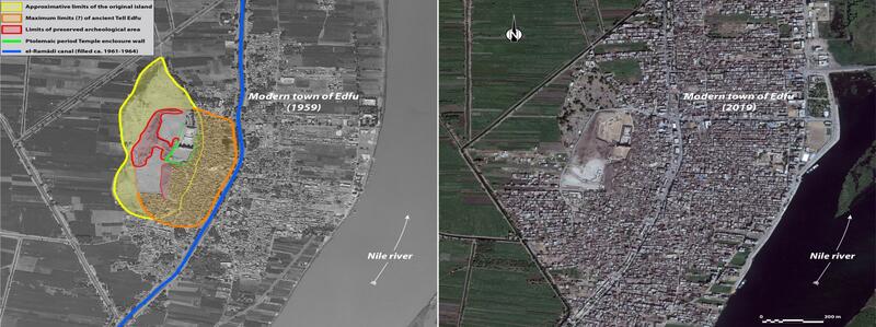
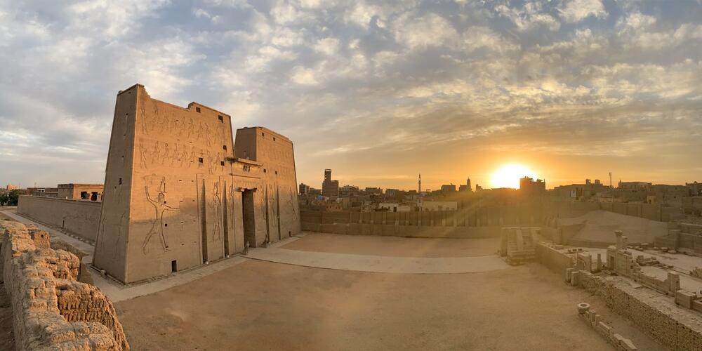
Fig. 2 –Limits of the settlement site at Edfu and the original island (1959 vs 2018). ©Tell Edfu Project
The ancient town of Edfu is situated on a naturally elevated sandstone outcrop on the west bank of the Nile, which provided the necessary protection from the annual floodwaters. Today the Nile lies 1.5km to the east of it, and we have little information on how this differs from the ancient course of the river. A detailed geomorphological study is still lacking, but first attempts have been made in order to reconstruct the river movement in the Edfu region from Pharaonic times to today (Bunbury 2009). The remains of the ancient town are located just a few meters west of the well-known Ptolemaic temple. They form a conspicuous mound or tell consisting of superimposed settlement layers, which encompass more than 3000 years of pharaonic period history. The earliest traces of human activity at the site date back to the Early Dynastic Period a latest phase of occupation dates to Coptic period. The tell in its current state still rises to a height of 10 - 15 m above the level of the temple entrance threshold and stretches 365 m from north to south and 168 m from east to west. At the turn of the last century, large areas of it were destroyed by sebbakh digging. The digging for fertilizer (sebbakh) resulted in major losses of the tell, forming quarry-like empty spaces in the southern and northern parts of the site. Further parts of the ancient town also surround the temple on its southern and eastern sides. Here much of the archaeological remains are covered by modern houses and are thus inaccessible for any large-scale excavation. The exact limits of ancient Edfu are clearly visible on satellite images. The city displays all the characteristic elements of an early urban center (temple and sanctuaries, administrative and elite quarters, large scale storage facilities, town enclosure walls, production areas, elite cemetery etc.), It is currently one of the last well-preserved ancient Egyptian towns that has still much potential for archaeological fieldwork in Upper Egypt.
The Tell Edfu Project started in 2001 as a mission of the University of Cambridge (Christ’s College) under the direction of Nadine Moeller, who was granted the concession of the site by the then Supreme Council of Antiquities (now Ministry of Antiquities and Heritage) of Egypt. After this initial survey work, excavations were initiated in 2005 under the same director, who was then Lady Wallis Budge Junior Research Fellow at University College, University of Oxford. In 2007, Nadine Moeller moved to Chicago for a faculty position at the Oriental Institute of the University of Chicago and brought the Tell Edfu Project with her. Since 2009, the project is also co-directed by Gregory Marouard.
Fig. 2 - Ongoing excavations at Zone 1. ©Tell Edfu Project
Since 2020 the Tell Edfu Project has been under the auspices of the Department of Near Eastern Languages and Civilizations, Yale University, still directed by Moeller and Marouard. The main research goals have been focusing on the origins of the ancient city in addition to exploring the various settlement quarters that are accessible on the current surface of the tell.
Since its inception, the Tell Edfu Project has investigated many different areas of the ancient tell focusing on the eastern portion of the tell which is situated next to the Ptolemaic temple. The main areas of research have been the Old Kingdom settlement area (Zone 2), the Governor’s Residence of the Middle Kingdom, and the silo’s courtyard of the Second Intermediate Period (Zone 1). Since 2018 excavations in Zone 1 were extended to the north and now include several large houses dating to the late Second Intermediate Period / early New Kingdom (ca. 1550-1500 BCE).
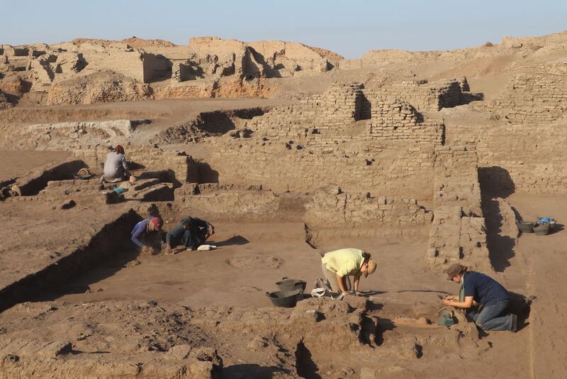
Fig. 3 - Ongoing excavations at Zone 2. ©Tell Edfu Project
The team has also created the Edfu blockyard, which allows for an open-air display of decorated blocks that came from the temple as well as the tell in addition to a smaller side project of cleaning and protection of small step pyramid in the nearby village of el-Ghonameya which dates to Dynasty 3 (ca. 2613 BCE).
History of Excavation
In the late 19th and early 20th centuries, it was common practice in Egypt to give permits to local farmers to extract the rich, organic soil of ancient archaeological sites to be used as fertilizers (sebakh) for agriculture. Tell Edfu did not escape this fate. While Auguste Mariette started clearing the Temple of Horus for the Antiquities Service around 1860, the ancient settlement area, was left to sebakkhin diggers who used the settlement site as convenient quarry for fertile soil. As it stands today, the tell is only a small portion that remains of the ancient city. The rest of the tell has been destroyed or is inaccessible for excavation as it extends underneath the modern town east of the temple. Other parts of the site were further removed between 1903 and 1905 when Alexandre Barsanti, working for the Antiquities Service, cleared an area close to the temple in order to temporarily store the blocks of the collapsing western temple enclosure wall which needed consolidation.
From 1914, until the outbreak of World War II in 1939, Edfu became a concession of the Institut Français d’Archéologie Orientale (IFAO) which is based in Cairo. The first seasons of excavations focused on finding Greek and Coptic papyri and were thus limited to the uppermost levels of the tell. Henri Henne directed the mission from 1921 to 1924, while Octave Gueraud took over in 1928. From 1932 to 1933, Maurice Alliot continued in his predecessors’ footsteps while also starting to explore the late Old Kingdom mastaba tombs in the ancient cemetery of Edfu situated in along the base on the south-western side of the tell.
In 1937, Tell Edfu became a Franco-Polish excavation under the direction of Bernard Bruyère and Kazimierz Michalowski. The excavation focused on the upper portion of the tell, where the team uncovered remains of the Coptic, Roman, and Ptolemaic town. This Franco-Polish mission was also interested in exploring the ancient cemetery and started the first systematic excavations of the late Old Kingdom (Dynasty 6, ca. 2345-2160 BCE) and Middle Kingdom (Dynasty 11-13, ca. 2055-1750 BCE) tombs. Work at the site was halted in 1939 with the outbreak of World War II.
It was not until 1975 and 1976 that archaeological work was continued under Manfried Bietak and Barry Kemp, who both conducted short surveys focusing on the earlier pharaonic settlement, never investigated by previous archaeological missions. Kemp was able to identify important settlement layers from the Old and Middle Kingdom. In 2001, Nadine Moeller (then Cambridge University) began the Tell Edfu Project, which sought to investigate these earlier remains. So far, the project has focused on three distinct areas of the ancient tell. Archaeological fieldwork has so far focused on:
- excavating a large silo courtyard of the Second Intermediate Period (Dynasty 17) overlying an older a Governor’s residence from the late Middle Kingdom (Dynasty 12-13) in Zone 1 which was extended in 2018 northwards and led to the discovery of the elite town quarter with several large houses which can be dated to late Second Intermediate/early New Kingdom period.
- the earliest occupation found at the site so far dates to the reign of Djedkare-Isesi of the late Dynasty 5 on the easternmost part of the tell (Zone 2) has been excavated and fieldwork is still ongoing.
- the investigation of the various town walls of the settlement inparticular along the northern limits of the site (Zone 3).
Further readings: