Tell Edfu - Uncovering a provincial capital in Upper Egypt
The origins of the ancient town of Edfu
The Old Kingdom settlement at Edfu (Zone 2)
The Old Kingdom town quarter is located on the north-eastern side of the tell (Zone 2), near the Temple of Horus, which corresponds to the only parts of the site where the archaeological strata dating to the 3rd millennium BCE are still accessible. It has been possible to follow the overall development of this settlement quarter, from the oldest layers of occupation founded directly onto the natural ground to the last preserved remains here which date to the First Intermediate Period (c. 2100 BC). It is now evident that this town quarter saw several phases of drastic transformations over time. The oldest remains so far unearthed are part of an ex-nihilo foundation, which is probably the result of the gradual westward expansion of the town from the south-east. The currently available archaeological evidence and preliminary geo-morphological observations suggest that there was a steady expansion from east to west, with the origins of the town that would have first been settled on a sandstone island delimited by a significant cliff on the eastern side. In Zone 2, the oldest buildings belong to a settlement phase that has been provisionally termed ‘monumental’ because of the large walls and sizeable buildings that do not show any of the characteristics of domestic architecture. Its foundation date to the late Dynasty 5 (ca. 2345 BCE), when two large buildings with associated courtyards and workshops were constructed. Based on their size, architectural details, and related finds, the two large buildings were of official nature.
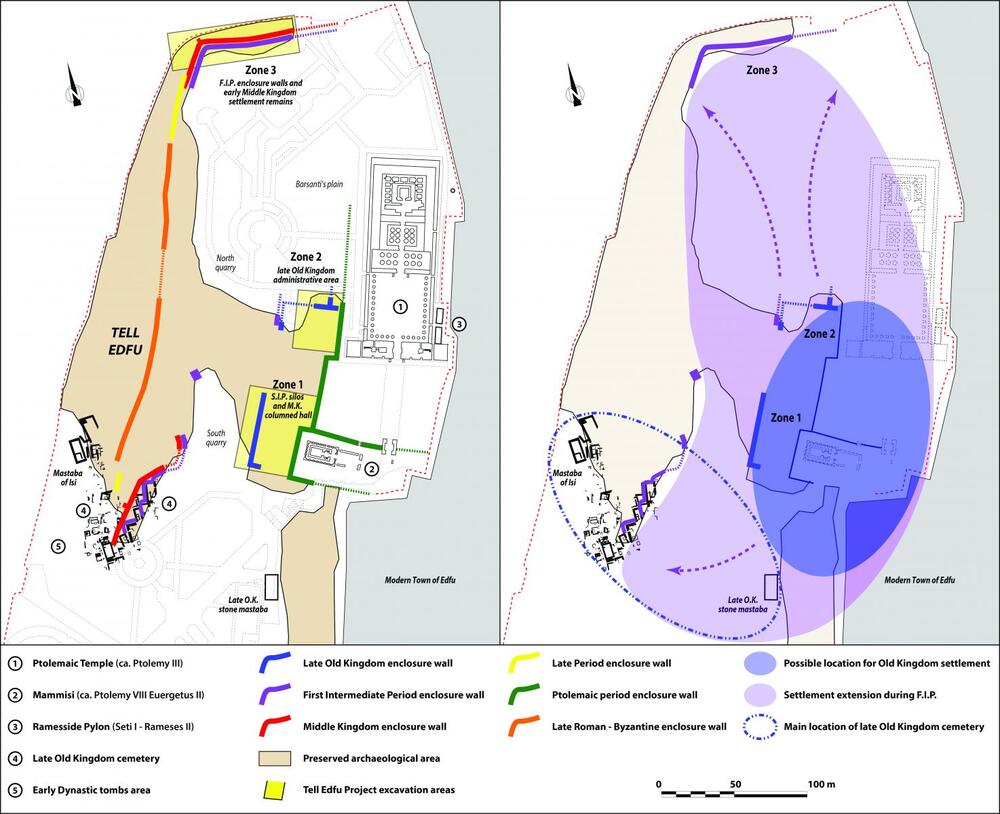
Fig. 4 – Schematic plan of Tell Edfu showing excavation areas, sections of enclosure walls and attempt to reconstruct the evolution of the settlement
between the Old Kingdom and the F.I.P. ©Tell Edfu Project
Workshops
On the northern side of Zone 2, which corresponds to the limits of preserved archaeological remains, two large rooms and a courtyard have been excavated showing many traces left by the various activities that had been carried out here. Several layers of occupation covering the corresponding floor levels have been excavated within the courtyard and the adjacent rooms that can be identified as workshop areas. They contain traces of numerous fireplaces with ash deposits in addition to important quantities of bread moulds and beer jars. This included a large amount of broken clay sealings from jar stoppers and other commodities such as bags, baskets and boxes which were found discarded in trash deposits. Some of them show traces of seal impressions and the best-preserved sealing is marked by a cylinder seal impression naming the titles of a priest and the Horus name of king Djedkare-Isesi, Djed-Khaw, the penultimate ruler of Dynasty 5.
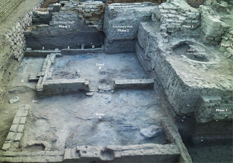
Fig. 5 - View of the workshop installations in the northern part of Zone 2 from the east ©Tell Edfu Project
These installations along the northern limit of Zone 2 indicate the presence of important workshops linked to official and administrative contexts as can be seen by the presence of broken clay sealings, the statue fragments and the traces of copper smelting which are typically carried out by highly skilled craftsmen, who were working for the elite and higher officials, and which were usually not part of domestic household activities. The processing of copper during the Old Kingdom was almost exclusively conducted under the supervision of official institutions, and the exploitation of this kind of raw material was exclusively organized by the central state under the charge of a high official personage sent by the king.
Remains two large buildings Northern Building 1 and Southern Building 2
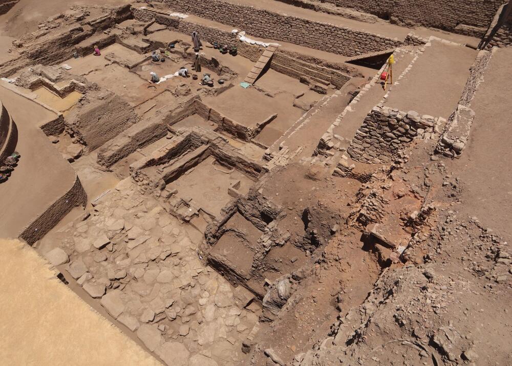
Fig. 6 – General view of the Old Kingdom buildings at Zone 2 in 2022 ©Tell Edfu Project
Also underlining the non-domestic character of the ex-nihilo foundation at Edfu in Zone 2 during the later Dynasty 5 are two large buildings situated along the western side of the zone stretching southwards. Only a limited portion of these buildings has been preserved, mainly their eastern facades, due to the removal of archaeological layers by the sebbakh diggers on the western side of Zone 2. Back in 2012, the massive exterior walls and the main eastern entrance of an important mudbrick building (Northern Building 1) had been discovered along the western edge of Zone 2. The eastern, northern, and southern outer walls have been preserved only to a small extent but on a significant elevation almost up to its original roofing, at about 2.50 m above the functioning floor level. Their unusual architectural features became apparent very quickly. Northern Building 1 is orientated east to west and only its eastern façade including the main entrance door is preserved, which consists of the wooden lintel and door still in situ. The exterior walls of this building are extremely thick and show a marked slope on its outside measuring between 2 and 2.5 m in width. These architectural features are rather unusual and have no parallels in the currently known archaeological record. As the archaeological evidence stands right now, no object that would provide any precise indication about the function of Building 1 has come to light. To its eastern side, Northern Building 1 was fronted by a large open courtyard. A thick perimter wall separates this building complex from another to the south, Southern Building 2 which also was built with substantial mudbrick but less wide than those of the northern building. The facades of both buildings are perfectly aligned, and they were founded on the same level indicating that they date to the same period and were conceived as a group. Another curious feature is that both buildings and a monumental stone platform on their western side, their purpose is not yet clear and unfortunately the corresponding floor levels on top are not preserved which makes it impossible for reconstruction their heights. For the Northern Builing 1 the internal spaces are almost not preserved while those of the SouthernBuilding are still being excavated. As mentioned above, both buildings functioned in tandem and were separated by the same perimeter wall that divides the area into two large square spaces. They clearly belong to the same construction project and all the components belong to the same contemporaneous building complex.
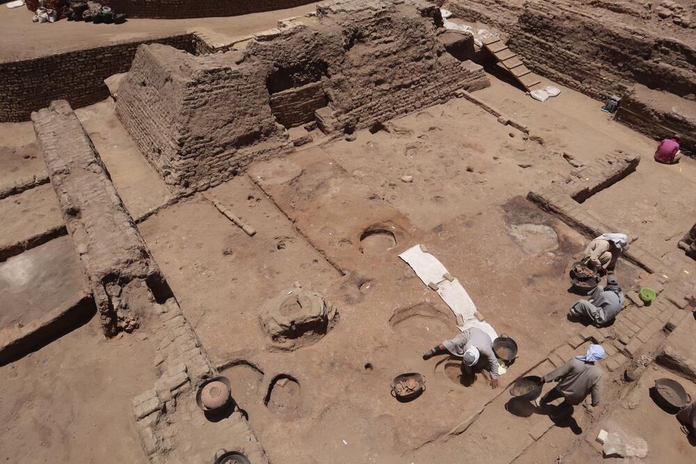
Fig. 7 – Ongoing excavation inside the eastern courtyard of the Northern building in 2022 ©Tell Edfu Project
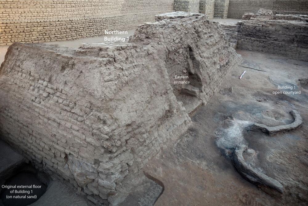
Fig. 8 – View of the eastern entrance of the Nortehrn building
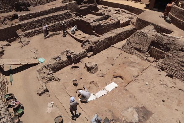
In Fall 2017, the entire exterior of Southern Building 2 was excavated, revealing intense cooking activities (bread and maybe beer production) and the presence of storage facilities (one granary and multiple large storage jars) mainly associated with several secondary rooms that were gradually installed in the vast space that had been marked originally by an open area to the eastern side, similar to the open courtyard east of Northern Building 1. During the very first phase of occupation, this area was a single open space, which was characterized by a thick brown organic layer (animal bedding) with multiple fireplaces and deep trash pits often containing complete beer jars and bread moulds. More importantly, a large number of broken clay sealings was excavated in this open area east of Southern Building 2, which were mainly found in one of the pits that had been cut into the first phase of occupation when this area was still an open courtyard, and prior to the installation of the various smaller rooms since they were found to be under the respective floor levels of these slightly later additions. These sealings show again multiple impressions mentioning the cartouche and Horus name of Djedkare-Isesi, which confirms the contemporaneity to the workshop area and associated sealing finds along the northern side of Zone 2. Most interesting is the fact that on several sealings a particular group of prospectors is mentioned, the so-called sementiu, who are usually associated with official expeditions and mining activities (gold, copper, and precious stones) in the Eastern Desert. Additional finds such as numerous pieces of copper ore, important traces of metallurgical activities, shells from the Red Sea shore, and a significant number of Nubian ceramics found on the floor levels during the excavation further confirm the link to royal expeditions and mining activities in the Eastern Desert.
 |
 |
| Fig. 10 – Ongoing excavation on the Southern Building in 2022 |
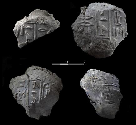
Fig. 9 - Clay sealings with the Horus name and cartouche of Djedkare-Isesi and the title of sementiu (prospector) |
As the evidence stands right now, it seems that the king might have sent an important official from Memphis to Edfu with the task to oversee mining expeditions into the Eastern Desert. This also fits to Edfu’s location with a direct access to the route through Wadi Baramiya towards the Red Sea. More excavations in Zone 2 are certainly necessary to confirm this current working hypothesis and the aim for the future fieldwork is to find out more about the precise function of these late Dynasty 5 complexes, which belong to the earliest phases of occupation in the city’s history so far uncovered at Tell Edfu.
Later installations in Zone 2
The two buildings remained quite important features in the area even after they had fallen out of use, which can be seen to the north of Zone 2 by a sequence of three phases of massive enclosure walls. Based on the stratigraphic evidence, these early Dynasty 6 walls clearly post-date the earlier settlement phase (they cover the workshop installation along the northern limit of Zone 2) and seem to have been deliberately avoiding Building 1 by constructing the walls in a peculiar way that make them turn in several right angles towards the north and east. Over time the entire settlement area then served as a large open dump and, only after Building 1 and 2 began to be covered up and were no longer visible in the urban landscape, the space was gradually colonised by various smaller courtyard spaces whose character is clearly of domestic nature. This key period, which dates to the turn of the mid-Dynasty 6 until the early First Intermediate Period (ca. 2200-2060 BCE) marks a rather radical change in function within this settlement quarter in Zone 2 from large well-built buildings of monumental and official character – with apparently a quite limited lifetime – to light domestic installations.
The development of Edfu at the end of the 3rd millennium BCE
As far as the overall chronological development goes, the foundations of the first ex-nihilo installations in the Zone 2 area date to the end of Dynasty 5, which indicates that this was the result of the gradual expansion of the ancient town of Edfu from its initial foundation further south-east, to the north-west. This might be linked to the gradual lowering of Nile flood levels during the Old Kingdom, in addition to making the best use of the available flood-free area that extended to the west, away from the river. Both possibilities could be related to a continuous growth in the number of inhabitants with the increasingly important status of Edfu as a regional urban centre. In addition to the new settlement quarter founded during the late Dynasty 5 in Zone 2, the agglomeration seems to grow rapidly at the end of the 3rd millennium BC and gradually takes possession of the entire surface available on the sandstone terrace/island.
A major phase of settlement growth and expansion at Edfu occurred at the very end of the Old Kingdom and transition into the First Intermediate Period (c. 2200 BC), which marks the maximum extension at Edfu ever reached in the northern and western directions. It is noteworthy that these are the only currently known limits, on the northern and western side, that did not considerably change during the remainder of the occupation of the town until the early Islamic period (10th century AD) when the tell was finally abandoned for settlement and occupied by a cemetery. During this transitional period, the ancient town had thus expanded to almost double its size in comparison to the earlier Old Kingdom and moved significantly further to the north and west. Recent fieldwork in Zone 3, which constitutes the northern limit of the tell, has shown that the first evidence for settlement including the construction of a thick enclosure wall occurred at the end of Dynasty 6 / early First Intermediate Period transition. This town wall was enlarged during the Middle Kingdom (Dynasties 12-13). It marked the limits of the town until Byzantine times. This 6 m wide enclosure wall consists of two separate mudbrick walls built one against the other, the outer addition dating to Dynasty 12. These remains clearly demonstrate that at the end of the 3rd millennium BCE, the inhabitants of Edfu had settled in a much larger area and invested much effort into a strong fortification system that lasted well into Dynasty 12.
Further readings:
- Moeller, Nadine. “The role of settlements and urban society for the history of ancient Egypt: The case study of Tell Edfu during the late Old Kingdom”, in: Schneider, T., and C. Johnston (eds.), The Gift of the Nile? Ancient Egypt and the Environment, University of Arizona, Tucson, 2020, pp. 87-105.
- Moeller, Nadine and Marouard, Gregory, “Excavation on the Old Kingdom Settlement at Tell Edfu”, OI News & Notes 244, 2020, pp. 10-17
- Moeller, Nadine and Marouard, Gregory. “The development of two early urban centers in Upper Egypt during the 3rd millennium BCE: The examples of Edfu and Dendara.”, in: Budka J. and Auenmüller, J. (eds.), From Microcosm to Macrocosm: Individual households and cities in Ancient Egypt and Nubia, LMU, Munich, 2018, pp. 29-58.
-
Moeller, Nadine and Marouard, Gregory. “Two Sister-Sites during the Old Kingdom: the Recent Results from the Settlement Excavations at Tell Edfu and Dendara.”, EDAL VI, Milan, 2017, pp. 204-215.