The Archaeology of Kurkur Oasis, Nuq‘ Maneih, and the Sinn el-Kiddab
By John Coleman Darnell and Deborah Darnell 1
Nearly one hundred years ago, Arthur Weigall was inspired by the excursions of Harkhuf, the Old Kingdom official who made at least four trips deep into the Western Desert to contact and “pacify” various Libo-Nubian groups, opening up a road to the south.
Although Weigall wrote vividly of the routes leading from Aswan across and beneath the Sinn el-Kiddab plateau, accessing the region of the Second Cataract and points beyond,2 his invitation to visitors to leave the attractions of Aswan for the roads of the southwest has attracted relatively few archaeologists and Egyptologists.
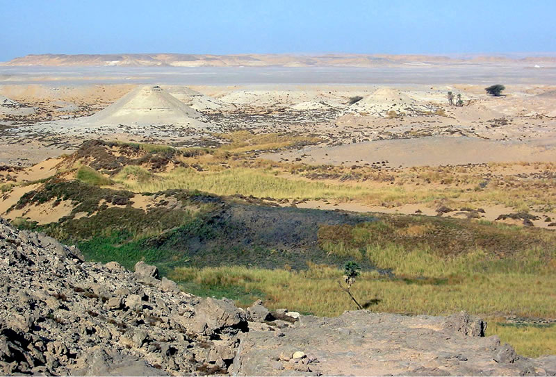
Earlier Work in the Vicinity of Kurkur
The Yale Toshka Desert Survey represents the first investigation devoted to assessing the presence and extent of evidence for activity in the small oasis of Kurkur (Figure 1) during the Predynastic and Pharaonic periods.3 During the Nubian Salvage Campaign of the 1960’s, an earlier Yale expedition studied Kurkur for about five days; although the expedition achieved considerable results of a geological and climatological nature,4 its archaeological observations were more modest, and are known only through a number of preliminary reports.5 Hester and Hobler published some additional archaeological material from Kurkur, as part of an expedition covering a larger area of the Sinn el-Kiddab and its western hinterland.6
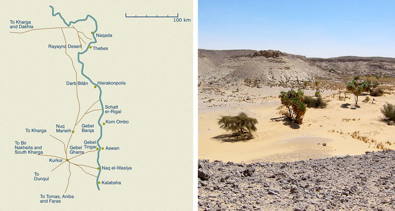
Routes Through and Near Kurkur (Figure 2)
Kurkur is the hub of several important ancient desert roads, linking the Thebaid, the First and Second Cataract Regions, Kharga Oasis, and points beyond.7 The Sikket Dehmit — leading to Nag el-Wasiya (the site of the rock inscriptions of the Nubian soldier Tjehemau) — and the Sikket el-Umbarakab — accessing the Bab Kalabsha — link Kurkur with the Nile to the east. The most direct route between Aswan and Kurkur left Aswan at Gebel Tingar, passing beneath Gebel Garra before reaching the Kurkur foreland.8 The Darb Bitân and the Darb Gallaba, north-south routes roughly paralleling the Nile, bypass the Kom Ombo region, the former accessing Kurkur directly from the north (passing through the Nuq‘ Maneih pan), the latter passing east of Kurkur and linking with the desert road to Kurkur from Gebel Tingar on the west of Aswan (Figure 3).9 Tracks from Kharga enter Kurkur from the West,10 and the southern routes out of Kurkur — one passing beneath the Sinn el-Kiddab escarpment, the other crossing the plateau and descending through the twin oases of Dunqul — gave the small oasis direct access to the area of Aneiba, and more distant regions.
Archaeological Remains at Kurkur (Figure 4)
The main concentrations of archaeological remains at Kurkur are in the Main Wadi near the modern wells, in the Northwest Wadi, and sparse and widely scattered material in the eastern foreland. Together these sites have yielded evidence for Predynastic through Roman and early modern activity at Kurkur Oasis.
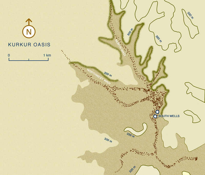
The Northwest Wadi
Extensive late Predynastic-Early Dynastic occupation areas occur in association with the caravan tracks running through the Northwest Wadi (Figure 5),probably the most heavily populated portion of Kurkur from the mid-fourth through the early third millennia BCE. During that period the desert dwellers in the area of Kurkur appear to have abandoned more widespread and less densely used campsites and workstations, increasingly focusing their activities on the Northwest Wadi. At the same time, pottery of Egyptian Nile Valley origin becomes fairly common at Kurkur.
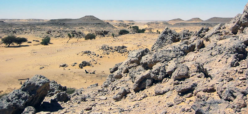
The Predynastic-Early Dynastic Site Near the Mouth of the Northwest Wadi
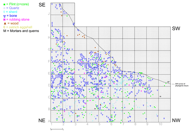
In the southern portion of the Northwest Wadi are the extensive surface remains of a Late Predynastic-Early Dynastic period habitation site, the densest portion thereof adjoining a large phytogenic mound. An initial examination of a 10m x 10m portion of the site has revealed a deflated desert surface covered by the remains of a food preparation area, the original surface of the site preserved in the lower portion of the phytogenic mound. The principal archaeological material comprised pottery, flint, quartz, bone, stone, wood, ostrich eggshell, charcoal and other hearth remains, and ochre (Figure 6). Numerous fragments of butchered animal bones are consistent with the preparation of wild game for consumption.
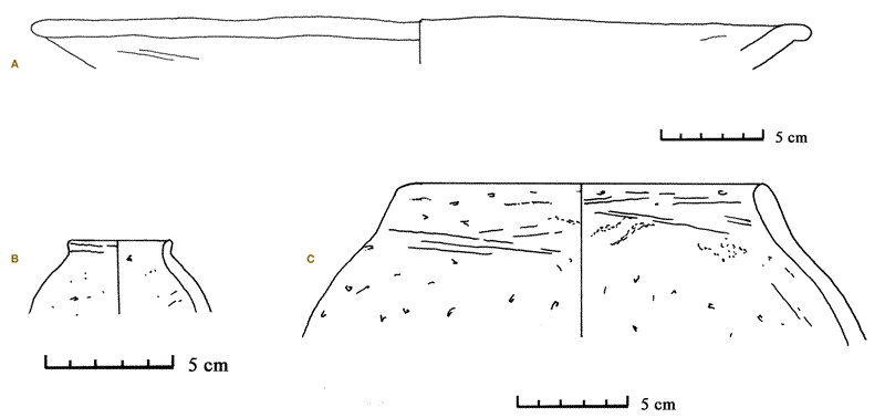
Abundant ceramic remains in the area include both Nile Valley Egyptian fabrics and desert-made, Libo-Nubian types. The former include “plum-red” polished ware, R-Ware, and Marl A1 (Figure 7a and 7b). Marl A1 occurs not only in the form of bowls and jars (including wavy-handled jars of Naqada II form), but also cut down into discs with central holes (Figure 7c), a peculiar item occurring almost exclusively in desert contexts, often in association with the enigmatic “lampshade” cylinders.11

The datable, Nilotic forms and fabrics at the southern site in the Northwest Wadi provide chronological anchors for the locally manufactured pottery, which is present in great abundance. Libo-Nubian handmade ceramics appear in a wide range of forms and fabrics, the latter including but not limited to low-fired silt with coarse organic temper, limestone-tempered silt and various locally-derived desert clays, often shale-tempered (Figure 8 and Figure 9).

Lithic material includes flint and quartz implements; wide expanses of the site are covered by animal bones, sometimes in association with butchering tools such as flint choppers. Charcoal is present, probably originating in ancient cooking fires.
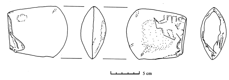
The large numbers of stone artifacts at the site include mortars (“metates,” Arabic raḥḥay), rubbing stones (“manos,” Arabic ḥajar er-raḥḥay), spherical pounding stones, celts (Figure 10), and bowls. Although the majority of the mortars and rubbing stones are of quartzite, the remainder of those objects — along with most of the the other stone artifacts — is of hard stones from basement rocks, such as basalt, diorite, dolerite, gneiss, and pink granite. Red Sea cowrie shells at the site are further evidence of long-distance trade.
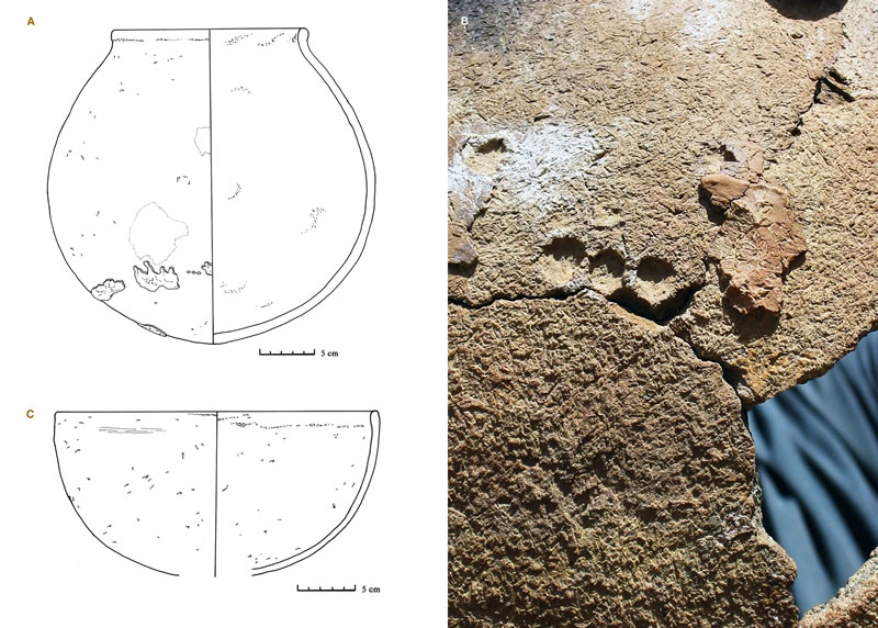
Material of a later date is also present at the site, in forms and wares that reveal an affiliation with the Kerma12 and C-Group cultures. These include globular silt vessels with a coarse, loosely adhering coating,13 some with remains of finger-sized circular impressions at the bottom14 and sides (Figure 11a, 11b), and large, hemispherical bowls (Figure 11c), as well as very thin-walled, red-polished, fine silt sherds (probably from Kerma Classic beakers).
Activity Toward the Head of the Northwest Wadi
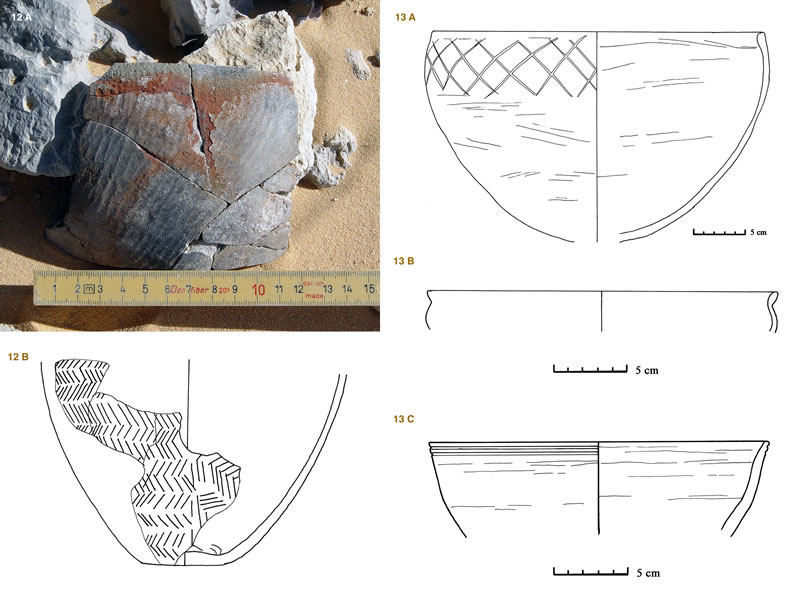
A short distance up-wadi is an even more widespread habitation site revealing considerable activity during the Late Predynastic Period, and extending through the early Middle Kingdom, with important assemblages of Nilotic Egyptian, Nubian, and Saharan remains. In addition to A-group material (Figure 12),15 considerable quantities of Nubian ceramic material from the time of the Old Kingdom through the early Middle Kingdom are present. This pottery exhibits characteristics of A-Group, Kerma Ancien, Kerma Moyen and C-Group types, combining fabrics, forms, and decorative traits in interesting hybrid forms (Figure 13a).16 Associated Egyptian material consistently dates this hybrid material to a period spanning the late Old Kingdom (compare the “Meidum” bowl in Figure 13b) through the early Middle Kingdom (compare the wheel made red-slipped Nile B1 bowl in Figure 13c).17 Much of this pottery is of local manufacture, suggesting — as does the findspot — a desert focus for this cultural group bridging the A-Group and C-Group horizons.
Eastern Foreland of Kurkur
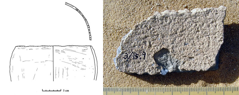
Remains in the immediate eastern foreland of Kurkur, just east of the Sinn el-Kiddab escarpment, are sparse. Numerous and widely distributed hearth mounds18 occur in the area. Pottery, though sparse, further demonstrates the association of early Nile Valley and Western Desert cultures. In addition to early Libo-Nubian/oasis ware, black-topped red ware sherds of very fine Nile silt are present. Among the significant pot drops in the area is a bowl of a desert fabric not uncommon at Kurkur (Figure 14a), containing abundant inclusions (including shale, medium to coarse sand, and mica). The exterior is roughly burnished and possibly once had a red slip; the interior surface is compacted and bears traces of hand-pulling and finishing with a cloth. The rim bears incised ‘ticks’, a decorative style perhaps related to the Abkan tradition19 that occurs at Rayayna and in the Kurkur Northwest Wadi as well, sometimes in a more exaggerated “toothed” form (Figure 14b).20
Area of the Darb Gallaba and Gebel Garra
Farther to the east of the Sinn el-Kiddab escarpment, Protodynastic, Early Dynastic, Old Kingdom, Middle Kingdom, New Kingdom, Roman, and recent sites occur in association with caravan routes, whereas evidence for earlier human activity (Early Neolithic to Predynastic/A-Group) includes both halting places along the ancient desert routes as well as occupation sites. Pre-pottery Early Neolithic sites (equivalent to Hester and Hobler’s “Libyan Culture”21) were numerous, and characterized by various types of dry stone features.
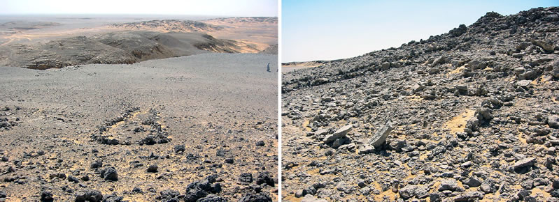
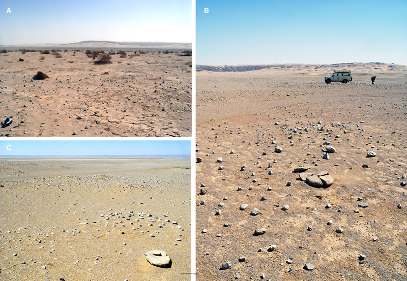
Stone features of Predynastic/early A-Group date were also in evidence, datable by associated pottery. The most singular examples were located at the point where an important ascent east of Kurkur reached the top of Gebel Garra south (the escarpment east of Kurkur). In addition to cairns, the site comprised a number of low stone lines in the form of “U”-shaped outlines, some of which were partitioned by transverse “walls” (Figure 15). The most imposing of these structures (including a roughly rectangular two-room outline) ranged from ca. 5 meters to over 12 meters in length; none of the walls exceeded .5 meter in height. In two cases, slab-like stones had been set in place on either side of the entranceway as “doorjambs.” Although the functions of such dry stone outlines remain obscure, parallel features exist on the plateaux of Kharga Oasis, Rayayna, and Naqada (in association with the Arqub el-Baghla pass). The Kharga features,22 high on the Darb Bulaq on the central eastern escarpment of the oasis, are particularly similar to the Gebel Garra features, both in terms of shape and size.
Ceramic material within and near the structures was exclusively of middle Predynastic date (late Naqada I through middle Naqada II), suggesting a similar date range for the structures themselves. The ceramic corpus at this locale is paralleled to a remarkably uniform degree by those at sites in the Rayayna Desert, specifically the Cave of the Wooden Pegs and the Rayayna Burial Feature.23 Both of these sites are on a major ancient route between the Nile Valley and southern Kharga Oasis, not far from that east-west route’s intersection with the northern extension of the Darb Bitan, a route directly linking Kurkur and the Sinn el-Kaddab with the Rayayna Desert in the north.

Ceramic evidence of pharaonic date near Gebel Garra south was sparse but significant, some sherds being of late Eighteenth to early Nineteenth Dynasty date and thus contemporary with the stelae of Tutankhamun and Sety I from the area.24 Extensive surveys of the northeastern scarp of Kurkur have revealed probable pharaonic patrol paths that the berated Medjay of the Tutankhamun stela may have used. A cluster of votive cairns and an associated hut mark the point at which the pharaonic aqaba of the Tingar route reaches the plateau. The grouping of small votive cairns is paralleled at Gebel Tingar, the Aswan terminus of this route, and on the pharaonic road system of the Theban Desert, often occurring at the point where the Nile Valley comes into view after a desert crossing.25 Ceramic material at this pharaonic aqaba includes Pan-Grave pottery, Nilotic Egyptian material of pharaonic date, and late Eighteenth Dynasty/early Nineteenth Dynasty imported Palestinian amphora fragments. A large, black-topped red polished, spouted bowl (in dung-tempered silt) cached in a large cairn near the track is evidence for C-Group use of the route (Figure 16).
Escarpment Between the North Wadi of Kurkur and the Nuq‘ Maneih Playa
The route through the Kurkur North Wadi across the northern escarpment descends to Bîr Wa‘ir and Nuq‘ Maneih, west-southwest of Kom Ombo. Predynastic (particularly Libo-Nubian) pottery and lithic material is present along the North Wadi route, confirming the early use of the track. In the vicinity of Wadi Wa‘ir, a gorge-like wadi into which the broad caravan tracks feed just south of Nuq‘ Menih, is both late (Roman) and important Predynastic Period material. The route passing to the east of Gebel Garra and linking the area of Kurkur with Nuq‘ Maneih also reveals considerable pre-pharaonic activity. Feeder routes lead from this track toward the Nile in the area of Wadi Kubbaniya and Naga‘ Qirmeila, and pass a high, sandstone outcropping topped by the substantial and well-preserved remains of a fortified monastery, where evidence of activity prior to the Coptic period includes pharaonic rock inscriptions and Predynastic rock art, as well as A-Group and Libo-Nubian pottery.
Nuq‘ Maneih (Figure 17)
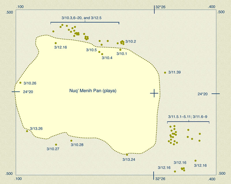
The site of Nuq‘ Maneih is a clay pan (playa) ca. 50 km west of the Nile, and ca. 20 km north of the point at which a traveler heading north on the caravan tracks through the North Wadi of Kurkur would descend the escarpment at the rear of Gebel Garra.26 The pan is situated between the high desert plateau to the west Gebel Barqa (Figure 18a, 18b) to the east. Scooped out of the middle desert surface by aeolian action, even today the vast plain with heights to east and west is the site of omnipresent afternoon whirlwinds that continue the eldritch erosion of Nuq‘ Maneih. This slight depression has long been the site of occasional pools of water, fed by desert deluges flowing through the small wadis that converge on Nuq‘ Maneih. Until relatively recently, the area has been used for seasonal pasturage and for growing crops after significant rainfall.
The Darb Bitân passes just to the west of Nuq‘ Maneih, ascending the gebel through Wadi Wa’ir on its way south to Kurkur Oasis; the Darb Gallaba passes to the east of Gebel Barqa. Lying between two major routes connecting the Rayayna Desert to the north and Kurkur to the south, two areas revealing considerable interaction between Nilotic Egyptian, Saharan, and Nubian cultures during the Predynastic Period, Nuq‘ Maneih provides important information about groups living between two major nodes of Predynastic cultural interaction.
A large number of sites, culturally uniform and of early Predynastic date, are distributed along the northern and eastern rim of pan (Figure 18c). The principal evidence of ancient activity includes hearth mounds and some burial tumuli (the latter concentrated on the slopes of Gebel Barqa to the east). Associated with the hearth mounds are grinding stones and rubbing stones; though quartzite predominates, as at Kurkur, some stones — e.g. basalt — were imported from considerable distances. Flint and quartz implements and debitage also appear, as well as fragments of celts and other small stone objects. Pottery is abundant at several locations, and is present at virtually all sites in at least limited quantities. Other camp sites occur along the Darb Gallaba, and scattered between that route and Nuq‘ Maneih.
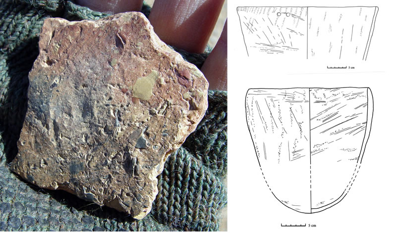
A range of ceramic fabrics is present at Nuq‘ Maneih, overwhelmingly of desert clay sources, and primarily local (including Kurkur/Sinn el-Kiddab wares). A varicolored (usually rosy peach, light brown and gray to black) oasis fabric with abundant coarse shale temper, virtually identical to the coarse shale-tempered fabric found in Dakhla Oasis,27 also occurs at and in the environs of Nuq‘ Maneih (Figure 19a). This fabric usually occurs in the form of simple-rimmed, open cook-pots with undulations (finger-channeling) and burnishing interior/exterior, for which many parallels occur at Kurkur, in the Rayayna Desert, and in Dakhleh Oasis. The exterior surface of Figure 19b is uneven due to the super-abundance of large, red, pale yellow and blackened tabular shale inclusions, with irregular rippling and haphazard smoothing marks; the rim was lightly pinched. The example illustrated in Figure 19c is tempered with gray shale, red ochre, and sand. Absent at the habitation sites in the environs of the pan is Marl A1, suggesting that — as in the lowest levels of the Rayaynan habitation (e.g. the Cave of the Wooden Pegs) — the earliest vessels of desert sourced clays predate contact with the pottery technology of the Nile Valley Predynastic. Ripple burnished and plum red sherds are present at Nuq‘ Maneih. Marl A1, and thus evidence of trade with Egyptians living in the Nile Valley, does occur on the Darb Bitan road near Wadi Wa’ir.
Other objects of note at Nuq‘ Maneih included quartzite mortars (Figure 20a) Object figure 28], from just outside of the pan proper, on the route between Nuq‘ Menih and Kurkur); quartzite rubbing stones (Figure 20b); tethering stones (Figure 20c); and numerous flint tools. The abundance of mortars and rubbing stones is astonishing, representing a remarkable variety of stones, including granite, dolorite, indurated limestone, and quartzite. Though in terms of the ceramic assemblage less cosmopolitan than their fellows at Rayayna, the inhabitants of Nuq‘ Maneih were unparalleled connoisseurs of grinding stones—their geological experience and trade connections were well developed.
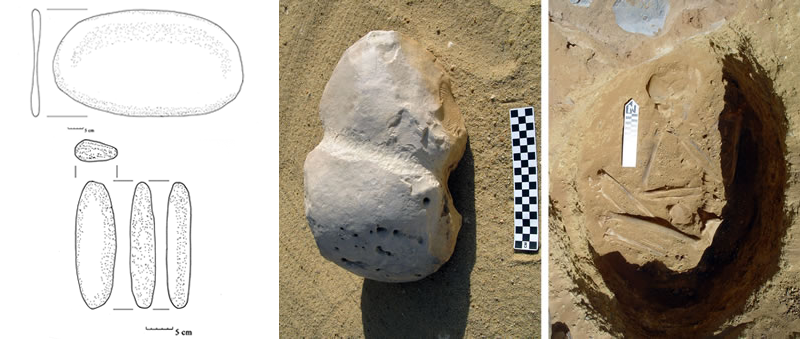
A small tumulus to the east of Nuq‘ Maneih covered a pit containing the body of a young adult in flexed position, head to the north and facing west, with no accompanying burial goods (Figure 21). Stones were placed directly atop the body within the pit. Bones not belonging to the complete skeleton were present as well, suggesting that an earlier burial may have been disturbed in order to make place for the later interment. In the northern portion of the clay pan proper were the disturbed remains of a dismembered skeleton that had apparently been buried beneath a stone pile, later turbated by plant growth. In the Rayayna Desert we have evidence of ossuary burials, and similar interrments are also known from Gebel Ramlah (between Nabta Playa and the southern Sinn el-Kiddab).28 The burial practices at Nuq‘ Maneih contribute to our suspicions — aroused by our work at Rayayna — that the desert communities along the Darb Gallaba/Darb Bitân route disinterred those who had died during preceding years’ treks, and brought the skeletized and dismembered bodies to major centers for burial. The practice of ossuary burial connects the Rayayna, Nabta, and Nuq‘ Maneih groups.
High Road between Kurkur and Dunqul
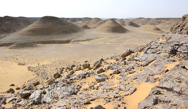
Our surveys of the route between Kurkur and Dunqul across the Sinn el-Kiddab plateau (Figure 22) have revealed a number of archaeological sites, the most extensive located near the midway point between Kurkur and Dunqul. This area shares features with sites in Kurkur, including hearth mounds and slab structures, and preserves evidence of intensive, early activity. Although some Predynastic Egyptian pottery is present (e.g. Marl A1 jars), most of the ceramic material at the site belongs to “Final Neolithic”/early A-Group/Libo Nubian cultures, linking such a presence at the nodes of the north-south routes through Kurkur — the Wadi el-Hôl and Rayayna to the north, and sites such as Gebel Ramlah and Nabta Playa to the south. Some material is paralleled in the Badarian, Tasian and Libo-Nubian corpora, with fabrics comparable to Late and Final Neolithic material from Nabta Playa. Also present are vessels of fine silt with interior/exterior ripple burnishing. Sherds belonging to Early Neolithic traditions also occur at the site (these include sherds identical with those of the Al Jerar phase, with Gatto’s R1 decoration type29), as well as at various sites in Kurkur, and reveal obvious connections between the Kurkur area and the Nabta region and points beyond.
Cultural Interactions and Desert Traditions of Kurkur Oasis: the Northern Connections of the Kiddabian Culture
Early ceramic assemblages at Kurkur find their closest parallels in the Rayayna Desert. The pottery in question includes sherds of vessels of early A-Group type, Nile Valley Marl A1 jars and bowls, oasis shale-tempered sherds, and local Kurkur/Western Desert fabrics. This assemblage (with material from Kurkur, Nuq‘ Maneih, and Bir Nakheila) allows a cultural identity to be assigned to “Desert Late Neolithic” material from sites along the Darb Gallaba-Darb Bitan route, and provides a chronological anchor for a period of intensive human occupation within, and traffic in and out of, Kurkur Oasis and Dunqul to the south, and the Rayayna Desert to the north. Remains at those sites reveal a cultural connection between the early A-Group of Lower Nubia and the Nubian deserts, and the early A-Group complex we have identified in the Theban Western Desert. The same “Libo-Nubian” A-Group population was evidently inhabiting, traveling, and controlling this desert corridor, and thus in practical command of the movement of materials and commodities between the Nile Valley and points to the south and west. Occasional Abkan sherds and some aspects of the rock art iconography of Rayayna suggest that the interactions of this cultural complex may extend into Sudanese Nubia.
The presence at Kurkur of a ceramic tradition that appears to occupy the period between the end of the classic A-Group culture and the arrival of the C-Group proper is consistent with what we know for the history of Eleventh Dynasty Theban interaction with Lower Nubia, and the apparent importance of the small oasis to early Theban expansionism during the Eleventh Dynasty. The artifacts at Kurkur reveal that — in spite of apparent depopulation along the Lower Nubian Nile — Kurkur, sitting astride major desert trade routes, remained a center of Nubian culture during the otherwise “Dark Age” of the late Old Kingdom through early Middle Kingdom in Lower Nubia. The apparent depopulation of Lower Nubia during the late Old Kingdom, prior to the arrival in the Nile Valley of the C-Group, must be seen in the light of a probable return of the Lower Nubian population to the Nubian oases. Remains at Kurkur suggest a continuation of life at the oasis, following a floruit during the late Predynastic and the Protodynastic Periods, with a renewal and population increase at the end of the Old Kingdom.
Nuq‘ Maneih reveals a Predynastic community apparently identical with the earliest Predynastic cultures of Kurkur and Rayayna. The major sites at Nuq‘ Maneih proper do not reveal any considerable interaction with Nilotic groups, as we see in the later phases of the Kurkur and Rayayna cultures, and the major settlement at Nuq‘ Maneih probably ceased when the desert groups began to have regular contact with Nubian and Nilotic Egyptian cultures. The material on the Darb Bitan itself, however, shows the passage of “Kiddabian” (Kurkur and Dunqul) and Rayaynan material. The time of the rise in importance of settlement at Kurkur and Rayayna sees the final phases of permanent or semi-permanent occupation at Nuq‘ Maneih. Interaction with Nubian and Nilotic Egyptian cultures corresponded to a time of abandonment of more marginal outposts by the desert groups, and their concentration in other areas, such as Kurkur and Rayayna, both the crossroads of major north-south and east-west caravan routes.
The archaeological material at Nuq‘ Maneih suggests that the Western Desert Predynastic groups of Upper Egypt — such as the Rayaynan Culture, related to the Tasian Culture, coeval with the Badarians, and having trade contact with the Abkan to the south — became increasingly sedentary as they began to interact with Nilotic groups. The desert communities concentrated their activities along the desert routes—their abandoning of the seasonally watered Nuq‘ Maneih for the more arid Rayayna Desert reveals that their association with the desert road traffic was more important and sustaining an economic strategy than the search for dwindling and ever more contested pasturage. The Kurkur/Kiddabian and Rayayna communities appear to have become important caravaneers, and in at least some areas — like Rayayna — the desert folk may have relied more on economic interactions with Nilotic and oasis groups than on their own agricultural endeavors and animal husbandry.
Notes
- 1. This is a shortened and photographically slightly augmented version of an article by the authors in D. Raue, ed., The Archaeology of the First Cataract (in press).
- 2. A. Weigall, “A Nubian Highway,” in: Travels in the Upper Egyptian Desert (Edinburgh, 1909), pp. 169-93.
- 3. For a preliminary presentation, see D. Darnell, “Gravel of the Desert and Broken Pots in the Road,” in: R. Friedman (ed.), Egypt and Nubia — Gifts of the Desert (London, 2002), pp.166-169.
- 4. Compare K.W. Butzer and C.L. Hansen, Desert and River in Nubia (Madison, Milwaukee, and London, 1968), with pp. 334-394 devoted to Kurkur.
- 5. Such as C.A. Reed, A Natural History Study of Kurkur Oasis, Libyan Desert, Western Governorate, Egypt, Postilla 84 (New Haven, CT, 1964); idem, M.A. Baumhoff, K.W. Butzer, H. Walter, and D.S. Boloyan, “Preliminary Report on the Archaeological Aspects of the Research of the Yale University Prehistoric Expedition to Nubia, 1962-1963,” in: Fouilles en Nubie (1961-1962) (Cairo, 1967), pp. 145-156. See also Butzer and Hansen, Desert and River in Nubia, pp. 389-394; K.W. Butzer, “Kurkur Oasis,” LdÄ III (1979): 884.
- 6. J.J. Hester and P.M. Hobler, Prehistoric Settlement Patterns in the Libyan Desert, University of Utah Anthropological Papers 92, Nubian Series 4 (Salt Lake City, 1969), pp. 133-152 (Kurkur).
- 7. See the preliminary presentation in J.C. Darnell, “The Route of Eleventh Dynasty Expansion into Nubia,” ZÄS 131 (2004): 23-37.
- 8. For the route from West Aswan to Kurkur see J. Ball, On the Topographical and Geological Results of a Reconnaissance-Survey of Jebel Garra and the Oasis of Kurkur (Cairo, 1902) 18-19.
- 9. For the Tingar road, see Ball, Oasis of Kurkur, 18-19.
- 10. J.C. Darnell, “Opening the Narrow Doors of the Desert,” in Friedman (ed.), Egypt and Nubia, pp. 149-150; J. C. Darnell, ZÄS 131 (2004): 29 n. 28.
- 11. D. Darnell, in: Friedman (ed.), Egypt and Nubia, pp. 159-160; H. Riemer, “News About the Clayton Rings: Long Distance Desert Travellers During Egypt’s Predynastic,” in: S. Hendrickx, et al., (eds.), Egypt at Its Origins: Studies in Memory of Barbara Adams, OLA 138 (Leuven, 2004), pp. 971-989. A possible Nile Valley occurrence may be P. Kopp, Elephantine XXXII: Die Siedlung der Naqadazeit, AVDAIK 118, (Mainz am Rhein, 2006), pp. 139 and pl. 29, catalogue no. 459.
- 12. For the lack of Kerma Moyenne material in Egypt proper, and the presence of Kerma material in the oases, see B. Gratien, “Kerma People in Egypt (Middle and Classic Kerma),” in: K. Kroeper, M. Chlodnicki, and M. Kobusiewicz (eds.), Archaeology of Early Northeastern Africa (Poznán, 2006), pp. 119-134.
- 13. Compare A. Vila et al., Le cimitière kermaïque d’Ukma Ouest (Paris, 1987), pp. 127-8, object 151/1, fig. 129; p. 197, fig. 220, no. 22/4.
- 14. Vila et al., Le cimitière kermaïque d’Ukma Ouest, p. 59, fig. 67.2, object 26/6; p. 138, fig. 144.1, object 171/2; p. 197, fig. 221, objects 154/5 and 42/1.
- 15. The shape and decoration are compatible with A-Group material — compare H.-Å. Nordström, Neolithic and A-Group Sites, SJE 3 (Lund, 1972), p. 76 (herring-bone pattern) and pl. 36, AIa19 (shape) and AIa23 (decoration). Sherds of apparently similar fabric and decoration also appear at Hemamieh (G. Brunton and G. Caton-Thompson, The Badarian Civilisation, and Predynastic Remains near Badari [London, 1928], pls. 72 [no. 121], 73 [nos. 147-148], and 85 [no. 211]) and at the “Saharan” sites of Armant (R. Mond and O.H. Myers, Cemeteries of Armant I [London, 1937], pl. 74, fig. 4).
- 16. For the shape compare D. Dunham, Excavations at Kerma, Part VI (Boston, 1982), pp. 230-232, types 114 and 119 (some with similar decoration); B. Privati, Nouveaux elements pour une classification de la céramique du Kerma Ancien (Genava, 1982), 57, Tomb 1, no. 1. For the decoration as present in C-Group, Pan Grave, and Kerma contexts, see B. Gratien, “Les pots de cuisson nubiens et les bols décorés de la première moitié du IIe millénaire avant J.-C., problèmes d’identification, ” CCÉ 6 (2000) : 114-115 and fig. 1, b and c., 120.
- 17. Compare E. Czerny, Tell El-Dab‘a IX: eine Plansiedlung des frühen Mittleren Reiches (Vienna, 1999), p. 146 (Nf160), early Middle Kingdom.
- 18. G. Caton-Thompson, Kharga Oasis in Prehistory (London, 1952) 166-167 and fig. 36; for the possibility of mound hearths, see Hester and Hobler, Prehistoric Settlement Patterns in the Libyan Desert, p. 52.
- 19. Compare Nordström, Neolithic and A-Group Sites, pp. 58-60 (note the red ochre coating on some vessels in Ware Group M4), and pl. 141, figs. 1 and 2.
- 20. The rim corresponds to J. Linstädter with U. Tegtmeier, Wadi Bakht, Africa Praehistorica 18 (Cologne, 2005) 128, fig. 9. The fabric is related — if not identical — to an oasis ware that fires to a buff-yellow color with a blue-gray core, common at Gebel Ghueita in Kharga Oasis for local versions of Nile silt vessel forms.
- 21. Hester and Hobler, Prehistoric Settlement Patterns in the Libyan Desert, pp. 51-57.
- 22. See Caton-Thompson, Kharga Oasis in Prehistory, pp. 43-45, pl. 124.
- 23. D. Darnell, in Friedman, ed., Egypt and Nubia, pp. 157-162.
- 24. J.C. Darnell, “A Stela of the Reign of Tutankhamun from the Region of Kurkur Oasis.” SAK 31 (2003): 73-91; idem., “A Stela of Seti I from the Region of Kurkur Oasis,” in S. Snape (ed). Studies in Honor of Kenneth Kitchen. in press.
- 25. Gebel Tingar: Weigall, Travels in the Upper Egyptian Desert, pp. 169-193; Wadi Mia at the Sety I temple: ibid., pp. 163-64; Hathor shrine at Serabit el-Khadim: W.M.F. Petrie, Researches in Sinai (London, 1906), pp. 63-65, figs. 75-76; Ain Amur Road from Kharga: Winlock, Ed Dakhleh Oasis: Journal of a Camel Trip Made in 1908 (New York, 1936), p. 44 and pl. 33; route from Dush in Kharga: Giddy, Egyptian Oases, p. 9; Gascou, Wagner, and Grossman, “Deux voyages archéologiques dans l’Oasis de Khargeh,” BIFAO 79 (1979): 4-7; Gascou, et. al., “Douch: Rapport Préliminaire des Campagnes de Fouilles de l’Hiver 1978/1979 et de l’Automne 1979,” BIFAO 80 (1980): 291-293 and fig. 3; Gebel Antef: J.C. Darnell and D. Darnell, “The Luxor-Farshût Desert Road Project,” in Oriental Institute Annual Report 1993-1994 (Chicago, 1994), available on line at http://oi.uchicago.edu/research/pubs/ar/93-94/desert_road.html (01.08.2008); J.C. Darnell, “The Narrow Doors of the Desert,” in: B. David and M. Wilson (eds.), Inscribed Landscapes: Marking and Making Place (Honolulu, 2002), p. 112.
- 26. Only G.W. Murray, “The Road to Chephren’s Quarries,” Geographical Journal 94 (1939): 100-101, has previously described the Nuq‘ el-Menih archaeologically. On the basis of Murray’s description of the site, Nuq‘ Maneih also appears in H.-J. Pachur, “Tethering Stones as Palaeoenvironmental Indicators,” Sahara 4 (1991): 13-32 (note the map on p. 15, fig. 1).
- 27. D. Darnell, in: Friedman (ed.), Egypt and Nubia, pp. 158-159, and 175 n. 2; C. Hope, “Early and Mid-Holocene Ceramics from the Dakhleh Oasis: Traditions and Influences,” in: Friedman (ed.), Egypt and Nubia, p. 40 (Masara Unit and noting that a coarse shale-tempered fabric was also used in the Old Kingdom) and 48-50 and pl. 59 (Late Sheikh Muftah use of a coarse shale-tempered fabric); idem, “Pottery Manufacture in the Dakhleh Oasis,” in: C.S. Churcher and A.J. Mills (eds.), Reports from the Survey of the Dakhleh Oasis, Western Desert of Egypt 1977-1987 (Oxford, 1999), p. 222, Group 3 (“Very coarse wares made in a heavily shale-tempered fabric fired a wide range of colors…”).
- 28. M. Kobusiewicz et al., “Discovery of the First Neolithic Cemetery in the Western Desert of Egypt,” Antiquity 78 (2004): 545-557.
- 29. See M.C. Gatto, “Early Neolithic Pottery of the Nabta-Kiseiba Area: Stylistic Attributes and Regional Relationships”, in: K. Nelson and Associates, Holocene Settlement of the Egyptian Sahara 2: The Pottery of Nabta Playa (New York, 2002), pp. 66-70. The fabric is probably Gatto’s Fabric I (Nordström Fabric IA), the fabric and decoration combination being Gatto’s Ware B — M.C. Gatto, “The Khartoum Variant Pottery in Context: Rethinking the Early and Middle Holocene Nubian Sequence,” Archéologie du Nil Moyen 10 (2006): 57-70.
