Umm Mawagir in Kharga Oasis: an Industrial Landscape of the Late Middle Kingdom, Second Intermediate Period
The most visible and well known ancient remains in Kharga Oasis are the well-preserved Persian through Roman Period temples that form ritual rest stops over a long north-south line from Hibis in the north to Dush in the far south, and the Roman cities and fortifications stretching from Ain Amur and Ain Umm Dabadib in the north to Qasr in the far south. Predynastic and pre-Persian pharaonic material in Kharga is sparse, and all but unknown north of Dush,1 prior to the work of the Theban Desert Road Survey and SCA excavations at el-Zahur and Ain el-Askar, and later the Kharga Oasis Prehistoric Project and the North Kharga Oasis Survey.2
Beginning first with the Girga Road connecting the Thebaid with Kharga, and then expanding to sites associated with the termini of the Theban desert roads within the oasis itself, the ThebanDesert Road Survey has recorded a wealth of Predynastic and pharaonic material, including Old Kingdom campsites, Middle Kingdom, Second Intermediate Period, and New Kingdom outposts on the high plateau, and Middle Kingdom tombs and a late Middle Kingdom through Second Intermediate Period economic center in the environs of Gebel Ghueita.

Already during an initial survey of the slopes of Gebel Ghueita during the ninth field season, 2000–2001, Deborah Darnell was able to conclude: “An initial survey of the environs of Ghueita Temple and the slopes of Gebel Ghueita yielded and astonishing amount of pharaonic ceramic material of Middle Kingdom through New Kingdom date. Many forms were present, the majority of oasis fabrics. This assemblage is the most conclusive evidence to date of a permanent pharaonic settlement in Kharga Oasis from the Middle Kingdom onwards.” Subsequent surveys of the hinterland of Gebel Ghueita have indeed led to the discovery of a major center of late Middle Kingdom through Second Intermediate Period activity, with associated sites of Predyanstic/Protodynastic and Old Kingdom activity.
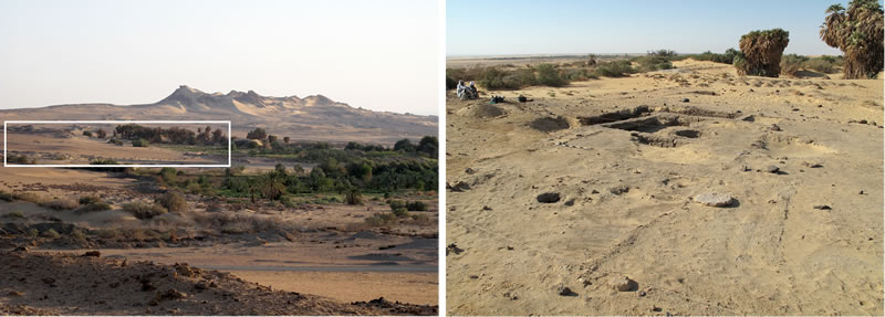
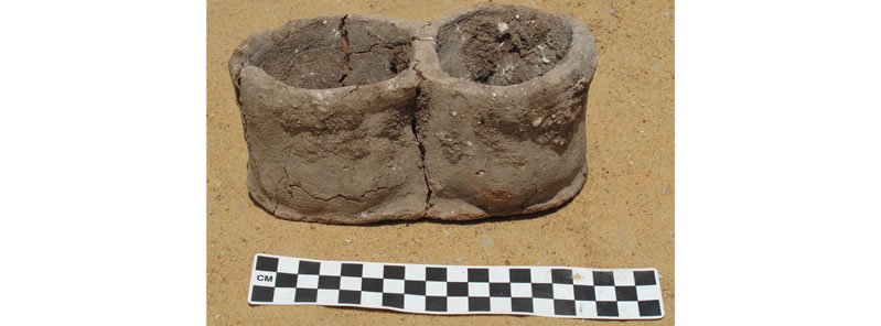
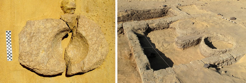
The site of Umm Mawagir — identified by the Theban Desert Road Survey in 2005 — preserves the first large-scale, non-funerary pharaonic structures within Kharga Oasis (Figure 1). From the lowest to the uppermost levels, the majority of ceramic remains at the site derives from double and single-bodied bread molds (Figure 2), hence the name we gave to the site: Umm Mawagir, “Mother of Bread Molds.” Excavations during the 2009 season corroborated our choice of name, and one 4m x 4m square within an area of debris contained nearly half a ton of bread mold sherds. Umm Mawagir was the site of large-scale baking and administrative activity during the late Middle Kingdom/early Second Intermediate Period, and is situated at the north end of what appears to be an almost continuous north to south strip of pharaonic activity and mud-brick constructions stretching from the Umm Mawagir site to the southern slopes of Gebel Ghueita. The Umm Mawagir site appears to have remained essentially undisturbed since its abandonment, apparently during the late Seventeenth Dynasty.
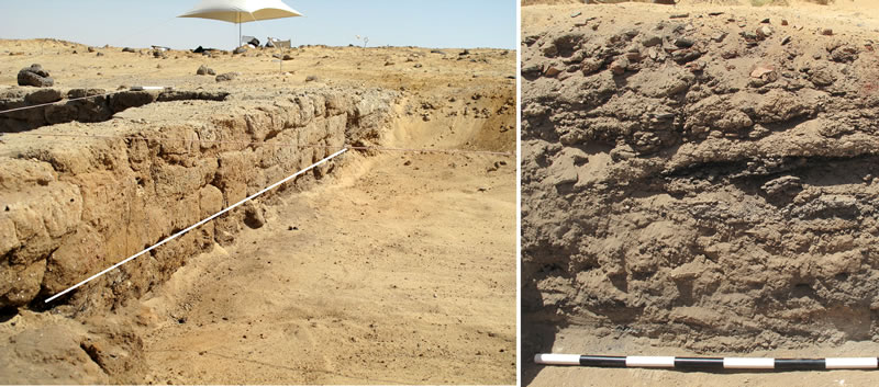
The site preserves the remains of numerous mud brick structures, preserved in many areas to between .5 and 1 meter in depth (Figure 3); most areas reveal two major use/construction events, with continuous accumulation of debris (Figure 4a). One of the most remarkable features of the site is the extraordinary accumulation of thick deposits of ash, charcoal, and sherds over the course of less than two hundred years (Figure 4b). The ceramic corpus at the site reveals the constant presence of basic forms from the lowest stratum to the surface material.
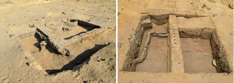
Material remains from the Umm Mawagir bakery indicate that every step in the baking process occurred in this centralized area (Figure 5a). The presence of grinding stones and a large quern at the north end of the site indicates grain grinding and the refining of the flour near and at the bakery proper. The potter’s wheels and exclusive use of oasis clay sources for the bread molds indicate that the bread molds themselves were made in this same area, and the abundant chaff inclusions within the bread molds may have been a convenient by-product of the grain grinding as well. The ovens within the mud-brick structure were certainly used for bread baking and perhaps as the kilns for the bread molds (Figure 5b).3 Further excavations at the site will hopefully elucidate the labor organization even further, but for now, the conclusive evidence for potters and bakers operating in a single portion of the site — possibly within a single construction — should be highlighted.
The consistency of the ceramic material — in terms of fabrics, relative ratios of forms, and overall ceramic corpus — from the earliest through the latest levels at the site indicates a massive effort at producing large quantities of bread within a relatively short period of time. The abandonment of the site after an apparently brief but intense period of use suggests that Umm Mawagir may be part of a complex, perhaps both administrative and economic in nature, purpose-built to fulfill a particular need during the late Middle Kingdom/Second Intermediate Period.
For evidence as to what military or economic undertaking Umm Mawagir was a response, we must await the finds of future seasons of work. The presence of a population in Kharga Oasis during the Second Intermediate Period producing pottery in local fabrics based primarily on late Middle Kingdom forms, with influence from Upper Egyptian ceramic traditions, having some trade relations both with Lower Egypt and Nubia — in conjunction with comparable material from other sites — has broad implications for understanding the economy and military history of the Theban Seventeenth Dynasty. The site of Umm Mawagir appears to have its twin in Dakhla Oasis, and the excavations of the IFAO at Balat/‘Ayn Asil have revealed a bakery area that has a similar architectural basis and ceramic corpus to that at Umm Mawagir.4 The amount of material at Umm Mawagir suggests that late Middle Kingdom and Second Intermediate Period Kharga may literally have been baking enough bread to feed an army; with her neighbor Dakhla perhaps doing the same at ‘Ain Asîl, that large population apparently living on the products of a communal baking effort — whatever their purpose — would have made a formidable force.
Notes
- 1. Wuttmann, M. et al., 2000. The Qanats of ‘Ayn Manâwîr (Kharga Oasis, Egypt). Journal of Achaemenid Studies and Researches, www.achemenet.com/pdf/jasr/jasr2000.1.pdf. We would also like to thank Colin Hope for comments on a version of the website text.
- 2. Kleindeinst, M.R., et al. 2006. ”Walking in the footsteps of Gertrude Caton-Thompson and Elinor W. Gardner: surveys by Kharga Oasis Prehistory Project (KOPP).” http://cohesion.rice.edu/CentersAndInst/SAFA/emplibrary/Kleindienstetal,M.SAfA2006.pdf; McDonald, M.A. 2006. Kharga Oasis, Egypt: key to timing transdesert contacts in the mid-Holocene. http://cohesion.rice.edu/CentersAndInst/SAFA/emplibrary/McDonald,M.SAfA2006.pdf. For the work of the North Kharga Oasis Survey, see http://www1.aucegypt.edu/academic/northkhargaoasissurvey/home.htm.
- 3. The kilns may also have been used for firing other types of ceramics; a very low percentage of the pottery around Structure A and in the radîm piles (in the north, bakery area) are waster sherds, but at Amarna, a potter’s workshop was excavated that had few waster sherds as well—see P. Rose, “Report on the 1987 Excavations: the Evidence for Pottery Making at Q48.4,” in B. Kemp, ed., Amarna Reports V (London, 1989), pp. 93-94.
- 4. S. Marchand and G. Soukiassian, Un habitat de la XIIIe dynastie — 2e Période Intermédiaire à Ayn Asil. Balat VIII (Cairo, 2010).
